Tag Archives: Kali Dak

Roopkund Chronicles – Day 3 – Ali Bugyal to Pathar Nachauni

Day 3: September 30

After a night of tossing and turning, we woke up at the crack of dawn.
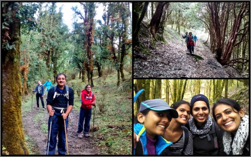
Walk in the clouds

Walk in the clouds

Imagine waking up and rolling out of bed to be greeted by a misty mountain view, with the sun peeping out and pink skies above you. Well, in a tent you do not roll out, but crawl out. For the next few days we were to follow a few steps, or rather crawls and crouches, while getting in and out of a tent.

While getting out of a tent

  • Unzip your sleeping bag, which invariably gets stuck, the more you rush.
  • Sit in a crouching position.
  • Unzip the inner tent opening.
  • Crawl out till the inner tent opening, still struggling to free yourself from the clutches of your sleeping bag.
  • Now sit back down and stick your leg out so that you can put on your shoes.
  • Unzip the outer tent opening.
  • Lift yourself up still crouching and walk out of the tent.


While getting in

  • Open the outer zip.
  • Open the inner zip.
  • Have your back against the tent door and fall onto your rear (ouch!!!), your legs still jutting out of the tent.
  • Remove your shoes and crawl into the tent.

PS: And every time you remove/put on your shoes while you enter/exit the tent….arduous!

Armed with our tooth brushes we walked towards the fiberglass tents. Ali Bugyal camp did not have a running water source so we had to make do with the minimal water available which was stored in plastic containers. When you’re deep in the woods, miles away from the nearest restroom, it takes some extra effort to take care of your ‘business’ in a hygienic way. With generous dollops of hand sanitizer, tissue paper and wet wipes, keeping clean was often a struggle.  Without the modern conveniences we’ve become so accustomed to, keeping up with the bacteria, dirt, and grime was a constant challenge. At least, everyone smells equally bad on a high altitude trek. But it didn’t matter – we were all bundled up in many layers to smother the scent. And who actually cared – after all we were not there to take part in a beauty contest.

Misty morning at Ali Bugyal

In ten minutes we were holding onto our glasses of hot tea and taking in the vista in front of us. Green valleys spread out before us with a few clouds looming in the sky. A thick layer of fog hung throughout the valley, making it impossible to see what lay behind. Above the fog layer, the sky was a mixture of grey and pink.

Kalidak and Trishul [courtesy Ammu]

Kali Dak and Trishul from Ali Bugyal [courtesy Ammu]

The weather cleared slowly, the fog lifted and as the sun broke through the clouds, we could see the rim of the snow capped mountains, jutting out like vanilla cones sprinkled with dark chocolate – we were pointed out the Trishul peaks, Chaukhamba and Kali Dak.

Chaukhamba from Aki Bugyal [Courtesy Ammu]

Rolling mist and Chaukhamba from Ali Bugyal [Courtesy Ammu]

We spent some time on a vantage point taking snaps till the breakfast call came.

@ 12000 ft

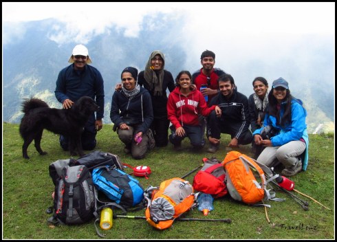
Heights of posing @ 12000 ft, Ali Bugyal

By 8.30 our luggage was loaded onto the mules and the first set of trekkers were already on their way. We walked up from the camp, passed a stone temple and were now hiking on the huge Z mark we had seen the previous day. The hike was not tough as we were passing on plain trails.

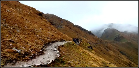
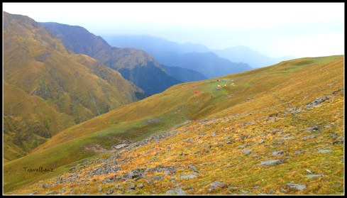
Our next camp was Pathar Nachauni, 5 km away. The trail to Pathar Nachauni was along a mountain edge, a narrow path with mountains on one side and a sloping valley on the other side.

Traversing bugyal land

Traversing bugyal land

In half an hour we were walking by another Himalayan meadow – Bedni Bugyal. Bedni Bugyal lay down in the valley on our left. In the middle of the grass land there was a pond – Bedini Kund. Locals believe that Maharishi Ved Vyas compiled all the four Vedas in this valley. There were two small stone temples near the Bedini Kund. We could also see a camping site, complete with a dozen tents and a couple of fiberglass tents.

Bedni Kund [Courtesy Ani & Sabari]

Bedni Kund [Courtesy Ani & Sabari]

We would be cutting through the Bedni Kund on our way back. There are two approaches to the meadows of Bedni Bugyal from the plains, one from Loharjung via Didna, Tolpani and Ali Bugyal – which we had taken – and the other, a steep climb directly from Wan village. We ascended through the first and would descend the other way.

Near the Kund, we could see a line of trekkers from another group. They were struggling as they climbed from the valley along a steep zig zag path to reach the main mountain trail we were moving on. We did thank our stars that we did not have to go through that steep climb in the morning. On our way back we would be taking that path down.

Trekkers climbing up from Bedni Valley

Trekkers climbing up from Bedni Valley

The trek today would take us through Ghora Lautani before we reach our camp at Pathar Nachauni. Ghora Lotani stands at a height of 3945 m and is about 2.5 kms from Ali Bugyal. It gets such a name because horses would never go up from this place – the place from where the horses returned home.

@ Ghora Lautani

@ Ghora Lautani

By 11 we reached Ghora Lautani. As there was a chance of rain, we were instructed to get into our rain wear immediately. The clouds had started to build over the mountains and there was an occasional peal of lightning accompanied by a flat rolling roar. Till now the nature Gods were pleased with us and we had not faced any showers, hail or snow.

Never ending trail to Pathar Nachauni

After Ghora Lautani, we had now moved onto the other side of the mountain. There were signs of major landslides that looked really scary.

Landslides at Ghora Lautani

Landslides at Ghora Lautani

The valleys looked browner than green, a sign that we were gaining altitude. The valley was covered with clouds which shielded the white peaks of Trishul and Nanda Ghunti.

Brown valleys at Ghora Lautani

From Ghora Lautani to Pathar Nachauni (1.5 kms), the trek was easy, almost going downwards. After 30 minutes or so we could spot a campsite on the right side, which belonged to another trek company, amidst an extensive alpine meadow down in the valley. The camp looked colourful with a dozen yellow and orange tents. Our campsite was further up on a ridge on the left side of our trail. By 11.50 we trickled into Pathar Nachauni. We were now standing on ground that was 12766 ft (3900 m) above sea level.

Reaching Pathar Nachauni camp

The camp consisted of two rows of 16 tents, 8 on one side bang opposite to each other. There was a huge mess tent, a few fibre glass tents and a shed for the mules. The toilet tents were placed further away up on the ridge. There was a small dhaba right in front of the camp.

Pathar Nachauni Camp

Pathar Nachauni Camp

We had barely reached the camp and it started to rain.

Slushy camp @ Pathar Nachauni after the rains and hail storm

The food provided throughout the trek by TTH was of top quality. Our menu was never repeated, and we were served with a variety of dishes. After a sumptuous lunch we thought we’d explore the place with Raj Bhaiyya. The rain had stopped now, but the whizzing Himalayan icy winds were on the prowl. Pathar Nachauni is a brown meadow, sprinkled with rocks – small and large.

Rocks and meadows @ Pathar Nachauni

Raj bhaiyya told us story, a popular folklore associated with the name of this place. A local King, on a pilgrimage to Nanda Devi, stayed at this place. He was traveling with a large group which also included a few dancers. The King got so lost in their performance that he finally forgot about the pilgrimage. Nanda Devi cursed the King and turned all dancing girls into rocks – thus the name Pathar Nachauni. An interesting story indeed.

The trail from Pathar Nachauni to Kalu Vinayak

The path from our camp led up to a steep hill and we were to follow this winding path tomorrow. The small temple of Kalu Vinayak lay somewhere amidst the mountains ahead of us. The trail between Pathar Nachauni and Kalu Vinayak is considered as the most difficult stretch to cover, because of the steep climb and altitude gain.

Team @ Pathar Nachauni...and don't miss the pink gloves [courtesy Ani & Sabari]

Team @ Pathar Nachauni…and don’t miss the pink gloves [courtesy Ani & Sabari]

 Tomorrow we would be camping higher – at the highest camp of this trek – Bhagwabasa. And tomorrow we would also get the first glimpse of our destination – Roopkund lake – or at least the mountain where Roopkund lay hidden in a shallow crater. Tomorrow is always better than today.

Day 3 in a nutshell

  • Day 3: Ali Bugyal to Pathar Nachauni via Ghora Lautani
  • Distance: Around 5 kms
  • Altitude: 11520 ft to 12700 ft [3510 m to 3900 m]
  • Terrain: Gradual ascent from Ali Bugyal to Ghora Lautani and downhill trek from Ghora Lautani till Pathar Nachauni.
  • Difficulty: Easy
  • Time taken: Around 3.5 hours


Roopkund Chronicles – Day 2 – Didna to Ali Bugyal

Room with a view

Room with a view

Day 2: September 29

We woke with the consciousness that we were into Day 2 of the trek. Though a bit chilly, we knew it was going to be a much warmer morning as compared to the ones we will wake up to in the next few days. There was yet another consolation in store – this was the last of the genuine (read non-pit) toilets for the week ahead – so there was quite a beeline for the toilets – both Indian and European for that matter –  already. By 7.30, we were all ready, breakfasted and even through with Raj Bhaiyya’s morning drill.

View from Didna

We set off at 7.45 am. There was a “slow trekkers” group formed on the basis of the performance that the guides made out on Day 1. They had already left about half an hour back and the rest of us also set out in trickles of small groups. We took our first unofficial stop in 10 minutes at a brook to top up our bottles. It was also the first time we were filling directly from a natural source – a sign that we were now high up and the water pure.

The climb, to begin with, was fairly steep and got our limbs working immediately. The ground was slushy, but navigable, and in no time our Quecha trekking shoes were smudged and dirty.

The entire walk is through a mixed forest covering the whole range of oaks, pines, deodars, and fir interspersed with broad leaved ferns and some brightly coloured mushrooms too. We must have ploughed on long enough to feel relieved at reaching a more level ground. As we walked out of the forest cover we spotted swirls of smoke – an evidence of inhabitation.

Walking into Tol Pani village

Walking into Tol Pani village

We had reached the small village of Tol Pani by 9 am, our first official stop for the morning. Though the trail was completely shaded we did feel thirsty after the steep climb. As we trudged through the village, we noticed the water source Raj Bhaiyya had mentioned during the morning drill. We were supposed to fill our bottles as this was the last water source before we reached our camp site, Ali Bugyal. The forest village comprised of a row of thatched houses interspersed with fields containing different crops. The forests provided not only fuel wood but also extensive grazing land for the livestock.

The beautiful forest village - Tol Pani

The beautiful forest village – Tol Pani

After Tol Pani, starts the almost vertical but zig-zag climb that passes through dense oak forests. We tried taking a few shortcuts, clambering across the tree roots, instead of walking along the well tread bridle path. But we realized that these shortcuts we took, shortened the journey, but the energy required was often greater than the time we saved.

We kept asking Raj Bhaaiya “How much more time?”, more due to our hunger than our tiredness. Whenever we asked our guides “How much further?” they would reply with, “Just half an hour more.” We would continue with renewed vigour and end up walking for more than 2 hours. Our incentive in the form of paranthas and boiled potatoes/eggs waited for us at Tol Top. There was just one agenda for us at the moment, to reach Tol Top and have our packed mid-meal.

By 10 am the difficult part was over and we reached a more level ground. The sun was barely trickling through the trees which had grown tall and bent over to form an extended arch. There’s nothing more enchanting than walking through a tree lined pathway carpeted with a permanent cover of moss and dry leaves, with the light spilling through the branches. For a few minutes we even forgot that we were at a height of more than 3000 m.

An archway of trees

An archway of trees

By 10.40 we emerged from the trees and walked onto a small ridge. We had reached Tol Top, the starting point of the famous Himalayan highland meadows. We flung our backpacks onto the grass and took in the views around. The faster trekkers had already munched onto their mid meals and were lazing around. From the ridge, the villages, houses, paths and fields appeared below. Everything looked so small from this height.

View of the villages and road from Tol Top

View of the villages and road from Tol Top

After all we had touched 3000 m. On a sunny day, you get clear views of Nanda Ghunti. Today was not our day; the mountains were hidden by a few low adamant clouds. Raj Bhaiyya pointed out a road in the distance – the road from Wan village which we would take back on our return journey.

 @ Tol Top with a furry friend

@ Tol Top with a furry friend [Courtesy Ani & Sabari]

We had lunch at the beautiful overlook, it just seemed like a good place to stop and eat.  After lunch, it seemed like too good a place to leave, but we had to move on.

Entering bugyal land [Courtesy Ani & Sabari]

This would be the last sign of forest cover we would see for the next few days. The bugyals spread out in front of us, strewn with tiny mountain flowers in all their beauty. We continued to walk through the charming meadows, for the next few hours, literally amazed by the beauty of this green expanse. The meadows were occasionally flanked by pine forests at the fringes. A line appeared to have been drawn by a ruler, separating the bugyals from the pine forests.

The clouds were dark grey with hints of a noon shower. It was a wonderful feeling, sauntering over the bugyals, running down a lot, clambering up a few, with only the grey misty skyline around.

The Ali Bugyal meadow stretched out far and wide ahead, but the camping areas are limited to the fringes of the bugyal, where there are sources of water.


By 1.00 pm we could spot our campsite in a distance. The campsite was located just on the side of a small mountain which had a huge ‘Z’ mark on it.


It took us another 20 minutes to reach the camp site – our first tented accommodation of the trip. We had walked for 10.5 kms today, climbed 1000 m and were now at an altitude of 11520 ft/3510 m. Our Ali Bugyal camp had 11 tents, 1 bigger mess tent, three fibre glass tents and a couple of toilet tents.

Further down, we could see a clutch of tents where a few Americans had parked themselves. By the time we had booked our tents by marking our territory with our back packs, we were called into the mess tent for a glass of warm lemon juice.

A lot of us wanted to sleep off our tiredness, but Raj Bhaiyya was not in favour of an afternoon siesta. Light exercises and activities during the day are better than sleeping because respiration decreases during sleep, exacerbating any altitude sickness symptoms. So to make us work out a bit, he decided to have a campfire that night. We would already cross the tree line by tomorrow and it would not be possible to find log and wood from next day onwards. Carrying those oak branches and wooden logs from a nearby forest was the acclimatization task for that day. We spent the evening playing games and singing around the bon fire.


The mountain views were still obscured by the clouds and mist. Somewhere in the distance Nanda Ghunti, Trishul, Kali Dak, Chaukhamba, and Neelkanth, were staring back at us.

It did get cold in the night, however, we all had our thick woolies on and sleeping bags. It was the first time for a lot of us – sleeping in a sleeping bag in a tent. It was easier said than done. But after a struggle, we could finally squeeze into the tiny space and lay down, two in a tent plus our 60 L back packs and 30 L day packs. We looked like a bunch of modern Egyptian mummies. The night went sleepless inside the tent, without being able to toss and turn. But just to realize that we were sleeping on a Himalayan meadow @ 11500 ft – priceless.

Tomorrow we would move to a higher camp, where the mountains are nearer, stars are clearer, air is thinner and the earth is colder. Tomorrow we move onto Day 3.

Day 2 in a nutshell

  • Day 2: Didna village to Ali Bugyal
  • Distance: Around 10.5 kms
  • Altitude: 8530 ft to 11520 ft [2600 m to 3510 m]
  • Terrain: Uphill trek from Didna via Tol Pani to Tol Top for the first three hours. Easy trek from Tol Top to Ali Bugyal for the last two hours.
  • Difficulty: Easy to moderate
  • Time taken: Around 6 hours including a mid-meal break