Category Archives: Arunachal Pradesh

Rubilu’s bamboo home

Where we love is home; home that our feet may leave, but not our hearts.
Wakro, in Arunachal, is inhabited primarily by the Mishmis. Mishmis are one of the many tribes that belong to Arunachal Pradesh. Divided into three sub-tribes namely Miju, Digaru and Idu, Mishmis are well-known for their expertise in weaving and handicrafts. One of our ‘not-to-be-missed activities’ during our stay in Wakro was to visit an authentic Mishmi bamboo long house.
In and around Wakro
The ‘other activities’ that we had planned were not less invigorating either. We were woken up everyday, before 4.30 am,  by the cacophony of birds and the hoots and calls of the endangered Hoolock gibbons, the only ape species found in India. As dusk descends early in these parts, by 4.30 pm it’s dark. With no TV, phone calls or internet to pester you, it’s always library time. After an early dinner it’s time for bed. Sleep came easy and why not? We had plenty of things to do between dawn and dusk.
The road from Wakro to Medo
Uncle Moosa called up one of his students, Rubilu, who was glad enough to show us her bamboo home. We headed to Medo village, 20 km from Wakro, to meet Rubi and her family.

We first went to meet Rubi’s aunt, Bihem, a government school teacher, who is also an organic farmer and a very strong crusader against the usage of opium. Opium smoking is an integral part of Mishmi culture and many of their ceremonies require its use.

In front of Bihem's home
Bamboo houses are built long and rectangular in size and are raised about 2 to 4 feet from the ground. The houses are supported by wooden or bamboo posts.  Beneath the house, domestic animals like pigs, poultry and goats are reared and sheltered.
The Mishmi bamboo homes  may not be lavish, but are cosy and exude warmth. Life is simple in these places, without ostentation, but the culture and traditions are rich.
Rubilu's home
Rubi’s father, the village headman and known in these places as the ‘Gaon Burah’, was having a meeting with a few gentlemen in the living room. Without disturbing the men we moved through the long corridor.  The corridor opened on the right side into many other rooms.
The kitchen was at the end of the corridor, and we smelt it before we entered it. Rubi’s mom had already placed a kettle on the fire and was preparing tea for us. On top of the fire,  was a rectangular wooden frame that lay suspended from the ceiling. This was used to smoke meat, corn and or even dry fire wood. We sat around the fire and drank the sweet and spicy black tea. The floor of the kitchen was made of thin reed planks and the waste water could be discarded  through the floor. Even the vegetable waste was deposited beneath the house where the pigs and other animals lived.
Rubi's mother

Rubi’s mother

Rubi’s mother looked different from the chubby Mishmi ladies we had seen around. She had high cheek bones and a leaner figure. Later we learnt that she belonged to a different tribe, the Khamti tribe.
Inside the kitchen

Inside the kitchen

The kitchen was devoid of any hi-tech gadgets but what caught our eyes were the rows of colorful bottles that lined the window sills. Pickled bamboo shoots, Bhoot jhalokia chillies and many other pickled edible fruits, roots and shoots filled the bottles.
Her small but modest kitchen garden had all kinds of medicinal herbs, edible plants and fruit trees. The granary, toilet and washroom were built away from the main house.
 Inside the living room, the walls were not only adorned  with lovely portraits of smiling and chubby Mishmi babies, but also with what looked like the remains of a kill. Seeing my aghast expression, Rubi’s father explained that the skeletal remains of Mithun heads, Gaur heads and other animals were not to showcase the fighting skills of the valiant Mishmi men but were only the skulls of the animals that were sacrificed by the family.
The wall
He also said that even in these modern days, people here prefer to live in their bamboo houses not only because of the fact that bamboo is plentiful here, but it also gave them a sense of pride and togetherness. Though a lot of modern concrete homes have come up in Arunachal, the common practice is to build a part of the home, mostly the kitchen and dining area, in bamboo and the rest of the rooms in concrete. It did remind me of the many ancestral homes in Kerala, where some of the rooms, mostly the bathrooms and kitchen, are modernized leaving the inner courtyard or ‘nadumittam’ intact.
Rubi with her father
Even as we made our way back to Wakro, we could feel the sweet spicy flavor of the black tea and the warmth of that humble bamboo home.
Thank you Rubi  for taking us into your home.
————————————————————————————————————————————–
[Here is a story written by Rubi that was published in Children’s World, May 2011.]
                                                                                                                                MY MOTHER

Rubilu

 Rubilu Dellang,

cl. VII, APNE Library volunteer

As soon as I was born, I was looked upon with great pride by my mother. I have also realized that my greatest supporter in life is my mother. I am very thankful to my maternal grandparents for giving me such an adorable mom. Let me tell her story…… My mother belongs to the Khamti society of Chongkham in Arunachal Pradesh, but my father is of Mishmi tribe. At the age of seven or eight, my mother started going to the fields to help her father (my grandfather), even though she was put in a school. When the school bell rang, she would rush to the nearby stream, wash her legs and hands and would run home. She would eat her breakfast quickly, dress up and would rush to her school. She failed in her class III exams three times, but she also enjoyed studying with her juniors! Actually my mom was very talented, because, even though she did not go to school daily, she learnt how to read and write well. In those days, studying was not so important for Arunachali girls, as it is today. My grandparents did not encourage their children going to school, as they gave more importance to working in the rice fields. So my mother gave up studies when she was in class eight. When my mother was fifteen, she fell in love with a handsome youth. Most girls and boys in the Khamti society find their own partners for marriage. It is a common custom even today. After she left school, her parents moved to an interior part of Chongkham, to a village named Manmao. From that time, my mother found it easier to meet my father. When she was twenty, she got married to my dad and they moved to a Mishmi village called ‘Hooking’. My mother told me that in his youth, father was very arrogant. But, after he was chosen as the ‘gaon burah’ (village chief ), he became quite friendly to all. After marriage, my mom did not get much importance at her new home, when compared to my aunts and uncles.  My paternal grandparents did not like my mother very much, as they liked my aunts and uncles. This was because she was not from Mishmi society. But at home, we and father love her very much. My mom and dad work very hard for us.

[Rubilu is a reader activist and library volunteer at the APNE library, Wakro. A bright student, she loves to write stories about her childhood and her village. She is now a Class X student in Government Higher Secondary School, Tezu.]


Wakro – Back to School

“I think I’m suffering from a “Writers Block”, I told my better-half one day.  “Isn’t that something that affects writers. Why should you suffer?” came his reply. I blast at him and prove (once again) that I was, after all, the worse-half.
I knew in my heart that I had been putting away this post for too long. As far as I was concerned, I had very good reasons. How was I supposed to write about home without mentioning my family. It’s difficult, but I had a promise to keep. I’m not going to name them or post a picture of them. But I’m going to write about them,  their schools, their work, their passion and everything else. This post is dedicated to a special ‘Arunachali couple’.
**********************************************************************

Wakro: nature fully loaded

In the distance, the looming hills of Kamlang sanctuary seemed to soften with the waning golden evening light. The ghostly swirls of mist added beauty as they curled around the barks of the abundant Hollong trees that stood in creepy silence. Birds kept flapping above our heads, trying to get back to their nests before dark. The road ahead of us was deserted; our Scorpio was the only vehicle competing with itself and trying to get on with the winding path ahead.
When Jayanto da took a sudden left turn and drove onto a mud path, we did not know what to expect. But we knew we were ‘finally’ home. We were in Wakro.
Orange Country

Orange County

Wakro – the land of oranges – something to compete with Nagpur – is a beautiful town in the Lohit district of Arunachal Pradesh. Did we  chose the wrong season to visit Wakro? We didn’t know that the small trees that lined the roads from Parasuramkund to Wakro were none other than orange trees, until Jayantoda pointed them out. So much for a masters degree in Botany!!
The orange orchards that spread across the Mishmi hills and valleys are nourished by the gushing waters of Lohit River. Wakro is also home to the Kamlang Reserve, a dense forest, with rich flora and fauna.  Tezu, the district headquarters, is located about 60 km from Wakro.
Anugraha

Anugraha

In front of us stood a single storey building. This tin roofed  modest structure may look ordinary to the common man. But appearances can be deceptive, as some extraordinary things happen here in this long house that doubles as an office and residence. This building, aptly named ‘Anugraha’, belongs  to an ‘Arunachali couple’  who  run two excellent and innovative  educational institutions and a library under the Anu Shiksha Seva Trust (ASSET) with the graceful blessings of His Holiness Swami Sri Sri Anubhavananda Saraswatijii.
Photo courtesy: Google images

His Holiness Swami Sri Sri Anubhavananda Saraswatijii

Happiness is a state that is envied by those who are not happy and enjoyed by those who are happy. But is happiness really as easy as it looks though? Yes, says Swami Anubhavananda, a philosopher and well followed spiritual saint. The ever smiling Swamiji’s motto is  “Be Happy” or “मौज में रहो “. Both the schools and the library have been inspired by this philosophy.
We seemed to be engulfed by this happiness the moment we stepped into the campus.   Apna Vidya Bhavan (AVB), an English medium semi-residential school and Kasturba Gandhi Balika Vidyalaya (KGVB), a special school for rural tribal girls funded by the  Government of India are located at a stones throw away. Apne Library, the  children’s library coordinated by the Vivekananda Trust and AWIC (Association of Writers and Illustrators for Children),  managed by ASSET, is located across the road.
Pick your school

Pick your school

ASSET has been contributing to the society by  promoting girl’s education in a big way. The school drop-out rates are considerably high, especially among girls, in these parts, and ASSET has tried to  change this tradition by convincing the village elders about the importance of education of the girl child to attain her rightful place in society.
KGBV, Wakro

KGBV, Wakro

The schools have come a long way from the days they started as a single classroom for nursery classes to a double storied school building with hostel facilities. At the schools, along with teaching the normal curriculum, the teachers try to inculcate the passion for all subjects. Children are also encouraged to read books and now Suppandi and the Wimpy kid are very much a part of their lives. The schools have also played an important role in keeping alive the traditions by including Mishmi weaving and knitting classes under the pre-vocational training programs, along with capacity building programs, fitness programs, and awareness programs on health and sanitation. The teachers and support staff are also subjected to regular training and orientation programs.
A class at APNA Vidya Bhavan

A class at APNA Vidya Bhavan

The APNE Library, the ‘Ranganatha Retreat’, is a tribute to two eminent personalities of the library movement in India, Swami Ranganathananda ji and Prof. S.R. Ranganathan.
Showcasing the Library movement

Showcasing the Library movement

 Swami Ranganathananda ji self educated himself from a hostel-cook to an international scholar through spirited reading and set up many libraries for poor youth in all of the Sri Ramakrishna Ashrams he lived. Prof. S.R. Ranganathan is the father of Library Science in India.
APNE Library, Wakro

At the steps of wisdom. APNE Library, Wakro

The girls of KGBV are active library volunteers, who during vacations, run holiday-libraries in their villages.The children regularly take part in library activities and have even formed a reading brigade that goes to other schools and encourages reading habits in other children. The library has also evoked enthusiastic response from the village elders.
Our own library: APNE Library

Our own library: APNE Library

The schools were closed for the Pooja holidays and the children were enjoying their vacations at home. For the next five days we stayed with Uncle at the APNE Library. The main hall of his modest two room home had been converted into a treasure trove of books. We literally felt like kids in a candy store.  Aren’t we all familiar with that musty smell of books? The trips to the library as a child or that cozy ambiance of a book store….. happy memories.

The library neatly stacked with a collection of more 1000 books ranging from Amar Chitra Kathas to Roald Dahl, and Ruskin Bond to Dr. Seuss.  Decked up with drawings and sketches and poems and photos and newspaper clippings, it was the true altar of the written word. Uncle doesn’t throw away a piece of paper. Every paper is recycled, be it an envelope, a pamphlet, or a calender. Colourful full length advertisements are cut out and customised into posters with peppy and innovative slogans.

Innovative recycling

Innovative recycling

There is more beyond the books stacked neatly in the shelves. There are frequent book exhibitions, reading sessions, workshops on improving reading skills, cultural and sports programs, environmental awareness and much more. The books in these libraries are donated by well wishers and publishing companies. Though it is Uncle  who co-ordinates the many little details that go into getting these books, the library is run by the “library activists” or “Reading Brigade” as uncle calls them. Come evenings, the  library turns into a hub of activities that include story telling, quizzes, booking readings, and enactments.
Uncle Moosa's 'Reading Brigade'

Uncle Moosa’s ‘Reading Brigade’

 The APNE Library at Wakro has also been staging small skits on little-known but inspiring personalities like Baby Halder, Dr. Usha Mehta, Dr. Kamla Sohoni, Rukminidevi Arunadale, Sri Aurobindo,  Anutai Wagh, Dr. Varghese Kurien and more recently Dr. George Washington Carver, the legendary black American agricultural  scientist of late 19th century.

George Carver skit team APNE Library Wakro

Each skit has a message. The reader-activists, all girls, perform the skits not only in English and Hindi but also in their mother-tongue,  Mishmi, so that the message reaches the common villagers too.  The girls take all the responsibilities from translating, preparing the script and rehearsing.  More lately, while performing skits in open noisy areas,  they have used  an audio-computer program where the entire dialogues are pre-recorded, and then later played at the venue.
Photo courtesy Sathyanarayanan Mundayoor

James and the Giant Peach team, APNE Library Wakro

The children are encouraged to write stories too. A lot of their stories, drawings and articles have been published in well known magazines like Children’s World and Dimdima Monthly, regularly. APNE Library has also the honour of receiving several  guests  including writers, research scholars, army and government officials, who keep inspiring the library reader-activists in many ways.
Photo courtesy Sathyanarayanan Mundayoor

Enacting John Carver skit

The continuous support of the Lohit Brigade and the 2nd Mountain Division of the Indian Army have gone a long way and
they have not only been sponsoring girls students and providing  free education and hostel facilities till secondary level, but have also played an important role in the development and adding new classrooms to the school.
We were also lucky to attend two functions arranged by the schools and ASSET.  The first function was to felicitate Brig Vikal Sahni, Cdr 82 Mtn Bde and Dr. Latika Sahni.   Apna Vidya Bhavan received a gift of Montessori Teaching Learning Aids from His Holiness Sri Sri Swami Anubhavananda Saraswatiji which was presented by Dr. Latika Sahni, Dean, Asian Business School.
Dr. Latika, herself an educator for more than two decades,  appreciated the APNEs and the educational environment maintained by ASSET in this remote rural region. It was so heartening to see Brig Vikal Sahni and Dr. Latika Sahni interacting with the children. The function was not only attended by teachers and students, but also by the parents and villagers. The guests were entertained by songs, skits and traditional Mishmi dances.
16102011_A1
The second function was a prize distribution ceremony in which we were made to distribute prizes to the kids who won the Solung/Rangoli competition. APNE Library had organized an Onam-Solung Rangoli contest  with a view to promote eco-awareness and cleanliness consciousness among the Wakro villagers. The contest  with the theme, “Clean Arunachal for a Happy Arunachal” – “Saaf Arunachal, Sukhi Arunachal” drew nearly 100 students from three nearby schools.
Photo courtesy Sathyanarayanan Mundayoor
We were happy to do our little bit of encouragement by giving away the prizes and the kids performed a few skits, songs and kept us entertained.

A skit on Sri Aurobindo being performed

There are two kinds of people: those who do all the work and those who take all the credit. In Arunachal we met a third kind – those who do all the work and who refuse to take the credit. Our dear Arunachali couple, who refuse to be named, give all credit to the blessings of  Swami Anubhavanandaji for the immense energy, generosity, and discipline under which both the schools and library are functioning. The time we had with the ASSET family, the children, and the schools was well spent. The work that has been done to shape and strengthen not just their education but also the inspirational activities where they get to express their creativity and talent for a good cause is commendable.
 I have always tried to write these posts in such a way that even after many years when I look back, I should be reminded of how I felt back then. Writing about the Arunachali couple, made me happy. I’m sure I’m going to feel that way always.

Wakro – a Prelude

Let’s first put a few realities on the table. Not many tourists have Arunachal Pradesh on their travel agenda. Which is just as good for those of us who want to keep their special discoveries all to ourselves!

And if you felt that there is a Tawang, that does catch a few tourists in the peak season, the truth is that there are many more such pearls tucked away in a green oyster that takes more than a touristy attempt at discovery. Scouring for the most popular North-east travel itineraries from the net or walking up to the travel agent office, down the road, will not yield much more than the West Arunachal  circuit of Tawang and Bomdila. Which is why we headed to the North-East – to the East of North-East.
Racing across the map

Racing across the map

So what do I now have to offer which I haven’t already shared with you. We spent a few moments at the War cemetery at Digboi, drove up the  Stillwell road till the Pangsau Pass at the Indo-Burmese border, played with the butterflies and dodged a few leeches in the woods of Namdapha, crossed the Lohit to reach Tezu, headed all the way up to Walong, reached out to distant Kaho and Kibithu and almost caught the first sun rays to fall on the Indian subcontinent.
Wakro, Arunachal pradesh (Google Map)

Wakro, Arunachal pradesh (Google Map)

There is still something left to be told, something really substantial and special that was, in fact, the reason that had us pack up our bags and head out to Arunachal in the first place – Wakro.
For starters, it happens to be one of the realities that we placed early on the table. Seeing it on the Google map is the stuff that gets the traveller in you to sit up. Typing in just Arunachal Pradesh on Google maps and without zooming in any further, you realise that Wakro is the furthest east that you can get anywhere in India. So much so that half of Burma, including Yangon, lies to its west. So, when we drove into Wakro in Jayanto da’s jeep, we knew we were in the east…seriously east.
As we climb down the mountains - Lohit river

As we climb down the mountains – Lohit river

Descending the last few bends in the ghat from our long drive from Walong, we passed the Demwe point where one road went on to Tezu and the other headed to Parshuram Kund. We took the latter and, shortly, reached the new bridge that sprawled across over the Lohit. All along the climb up to Walong and down it, watching the river from the IB at Walong and crossing over it on the hanging bridges, we had seen Lohit in all its many moods. But this was different. We were staring down at it from really up close and from the ‘comforts’ of a concrete bridge.
Parashuram kund bridge

Parashuram kund bridge

Ahead, the famous sight of Parshuram’s axe embedded in the river bed heightened the drama that was already quite dramatic. We parked our Scorpio at the base of the bridge, climbed a few steps till we reached a temple. There were a few men dressed in saffron sitting around a Banyan tree.
Walking to the ghats

Walking to the ghats

We walked further, passed another temple, and a few more smaller shrines,  and proceeded to climb down the steps that were built to accommodate the thousands who flock here every January during Makarsakranti to take a dip in the freezing waters of Lohit. For now, we were the only people around.
The temples, shrines and holy men on the way to the kund

The temples, shrines and holy men on the way to the kund

Every year, Parshuram Kund Mela is organized  in the month of January from 13th to 15th. On Makar Sankranti day, large numbers of devotees come here to take their holy bath. Legend says that when Parshuram killed his mother with an axe at the behest of his father, the axe got stuck to his hands. In order to get rid of the axe, and the sin of killing his mother, he came to Brahma Kund where he took a dip in the holy water. Magically, the axe immediately fell from his hands. He picked up the axe and threw it as far as he could into the mountains. The axe split the mountains, and the spot where it fell became the Brahmaputra River.
The axe seen from the Parasuram Kund bridge

The axe seen from the Parasuram Kund bridge

Beyond the Parshuram Kund, the Lohit River is known as Brahmaputra.
Jayantoda told us an interesting fact about Parshuram Kund. During Makarsakranti, only those whose parents have passed away can take a dip in the Lohit River at the Parshuram Kund. The rest take a dip across the Kund in the Brahmaputra River.
The iconic 'axe' at Parasuram Kund

The iconic ‘axe’ at Parasuram Kund

Down at the last few steps just above the river, we felt the naked fury of the Lohit as the blacks, the dark greens and the frothy whites all tossed up as if in a super strong blender. In front of us, the “axe” with its jagged edges protruded resolutely over the swirling waters.
Close encounters with the 'axe'

Close encounters with the ‘axe’

Wakro was just 20 km up ahead. A brief stop for a cup of tea later, we were crossing the Kamlang bridge and waiting with bated breath for the first sight of Uncle Moosa’s ‘home’ town. Uncle, an Arunachali at heart and by the sheer fact that the last 30 years of his life have been spent in Arunachal and among its lovely people, currently works and lives in Wakro.
From here on Lohit is known as Brahmaputra

From here on Lohit is known as Brahmaputra

For the next five days we would be with Uncle, sharing or rather encroaching upon his space, spending time with him at the Apne library, with his books, with his little patrons from Apna Vidya Bhavan and Kasturba Gandhi Balika Vidyalaya, with the wonderful staff of these fine two schools and, never the least, the two remarkable people who started and run these excellent institutions under the Anu Shiksha Seva Trust (ASSET) with the graceful blessings of His Holiness Swami Sri Sri Anubhavananda Saraswatiji.
Well, that will need a whole lot of a chapter.

On the Eastern Most Road of India – to Kaho and Kibithu

Half a century ago, India suffered its worst military attack, and subsequent defeat, throwing open a gaping hole at the border, and proving how unprepared India was, militarily and politically. On the 50th anniversary of the Chinese invasion, this post is dedicated to some of our bravest soldiers who fought, who died, and who went missing during Indo-China War, 1962. 

*********************************************************************

In November 1962, TIME magazine paid a tribute to the Indian soldiers who fought in the Indo-China War in Walong.  It said, ‘At Walong, Indian troops lacked everything. The only thing they did not lack was guts’.

Time Magazine November 30 1962  (ed)[http://www.time.com/time/covers/0,16641,19621130,00.html]

In October 1962, when  the Chinese planned their incursion into the north-eastern sector inIndia, a region they would later call the “Tiger’s mouth”, they exposed the unready state of the Indian military. At the same time, what stood out was the heroic resistance of the Indian soldiers. The tragic bloodshed took place around the hills in Namti , near Walong, which has a special place in the history of India’s battles.

Rise and Shine – Walong Valley

From 22 October 1962 till the fall of Walong, on the 16th of November 1962, soldiers from the Sikh, Kumaoni, Gorkha and Dogra regiments fought a common enemy, shoulder-to-shoulder, in this unknown territorry. Ill-equipped and totally under prepared for such battles, some of the soldiers had to withdraw, crawling through the treacherous terrain. The rest of the soldiers never received any orders. Totally cut from their battalion, the soldiers fought it out to the last bullet, to the last man, till there was nothing left.

When the firing was over, and cease-fire declared, the army returned to the inhospitable terrain only to find that the Chinese had marked the positions of the dead. The Indian bunkers showed the dead where they had last manned their weapons. The Chinese had at least paid respect to their dead enemies – all the bodies were covered.

It is not uncommon to find the remains of the war, even now. Burnt pieces of army uniforms, fire arms, live ammunition, and other personal items lie scattered under rocks, tall grass and pine trees on the mountains.

People pay tribute to Sepoy Karam Chand Katoch (Inset) in Palampur [Photo Courtesy PTI]

In July  2010, the Border Road Task Force found a circular identity disc, PIS No. 3950976, and a silver ring, while clearing landslides in Walong. When the army checked the war records, they found that the disc belonged to Sepoy Karam Chand Katoch of the 4th Dogra Regiment. The local army unit  then dug the area and found the remains of Karam Chand, along with a fountain pen, dilapidated pay book and a few ammunition. His mortal remains were flown to his home in Palampur, in Himachal Pradesh, from where, as a 19 year old soldier, he had left home  to fight for his mother land. Before they flew his mortal remains, he was given a full honor salute at the War Memorial in Walong.

How tragic that the selfless acts of bravery goes unknown to the majority of Indians?

Around the Walong circuit house

The next morning, up early, we drove further east. The first stop, just outside Walong town and past the Army complex, was the memorial built by the Lohit Brigade to salute the brave and selfless sacrifices made by the Army men during the 1962 war. Known as the ‘Hut of Remembrance’, here the names of each of the martyrs who had laid down their lives in defence of the Lohit valley in 1962 is etched in marble.

Hut of Remembrance at Walong

We spent a few minutes walking around the black marble plaques, reading the names of the young soldiers who fought on the rugged mountain tops, suffering from extremes of cold, hunger and thirst, only to lay down their lives for our better tomorrow.  It was a sombre moment for both of us.

The war memorial and epitaph that I mentioned in the previous post stands on the Namti Plains, by the Lohit River, to commemorate the exemplary sacrifice of our brave soldiers.

At the hot springs in Tilam

But before visiting the war memorial we had to take a detour to Tilam.   Just 4 km out of town, Tilam is known for its hot springs that, reportedly, have medicinal properties. On the banks of the springs a brand new circuit house was getting readied. We parked in front of the circuit house and walked down to the springs. Though a bit dirty, the water was boiling hot.

The hanging bridge on the way to Dong

We walked a bit further over a hanging bridge to where the climb up to Dong village begins. Overlooking Burma and China, this village has cornered the distinction of being the Indian habitation to catch the first rays of the sun. It’s a climb of an hour and a half hour which needs to be commenced at 3 in the morning, and not without a guide or a local.

It was in the turn of the last millennium when flocks of tourists swarmed to the hill top here to catch the first rays of the first sunrise of the 21st century light up the Dong valley and, in time, the rest of the country. We wanted to walk to ‘Millennium Point’ at Dong but we had to take permission from the Indian Army and without a permit no one could go.

Namti Plains

Promising that we would take the walk to Dong the next time, we climbed back into our vehicle. Our next destination was Kaho. On the climb up to Kaho, there was little traffic. The Namti plains stretched before our eyes, pretty and pine laden. After a brief stop at the war memorial we proceeded further.

War Memorial at Namti Plains

With every turn, the mountains on the Chinese side grew larger in view. The settings were so surreal. I was trying to imagine the place about 50 years back. A yellow board reminded us of being on the eastern most road in India.

On the eastern-most road in India

We crossed a few metal bridges and were now driving along the Lohit River. Jayantoda mentioned that all these bridges had been replaced recently from the traditional ones. A ‘traditional’ one still hung precariously a bit further. We were standing in front of what the Mishmis call a ‘bridge’. In reality, it was just a lot of planks tied together that straddled both the banks of the Lohit. At that great height, the uncontrollable swing of the bridge and the turquoise water raging down below, a walk up to the other end and back needs some steely nerves. And I had to do it.

On the hanging bridge near Kaho

Mission accomplished, we drove into Kaho, a small village on the eastern most border, situated in a small valley surrounded by towering mountain peaks, most of them on the Chinese side. Kaho has around nine households. Cutting into the serenity of this small village is the constant presence of the Army all around and after all, the Line of Actual Control is not too far from here. Besides the village school, a monastery and a small tea shop cum PCO, Kaho is all about silence and the virgin beauty that the landscape offers.

Kaho village

We walked in to the Lohit Goodwill school and said hello to the children there. The teacher, apologetic about the poor attendance – the school had just reopened after Dushera –  showed us into her class rooms. There were only four children, five were absent. The teacher herself had reached the previous night from Tezu, her home town, after the holidays.

Lohit Goodwill School

From the school we walked up to the monastery only to realize that it was closed. A short climb up from the monastery is an Indian Army outpost and we paid them a courtesy visit. The two jawans at the look out were gracious enough to point out where the border lies and the various peaks on both sides and allowed us a quick peek through their binoculars at Chinese side.

“I can see a house with blue paint”, I said triumphantly. “Well, the Chinese can see the print on your dress, Madame”, one of the jawan said teasingly. “They have a binoculars powerful than ours and they are constantly monitoring the civilian traffic in our area. If they see more traffic, they get stressed out and if they get stressed out, it indirectly affects our sleep”. For civilians like us this journey is just a picture in an album, a page in a book. For the army its the whole volume.

The blue houses on the other side

On the way back, we drove up to Kibithu, currently the brigade HQ of the Indian Army.

Kibithu

Here civilian entry is monitored if not entirely restricted. We had to give our details at the check post. The helipad here used to be an attraction for the great views it offered. Presently, it is out of bounds for anyone who is not army and photography is not permitted.

Kibithu – Army camp

We stopped for lunch in one of the small restaurants there. I never knew that the humble 2-minute Maggie could be so delicious.

The first glimpse of Lohit River entering into India [the furthermost mountains are in China]

There was one more place to visit before we drove back to our guest house. Equally touching and another must-see point in Walong is the Helmet Top, 18 kms by road above Walong. A patriotic pilgrimage of sorts that every Indian needs to take, Helmet Top was once a vantage point for the Indian army. During the war, a few of the Indian soldiers were stranded here. None of their counterparts back at the headquarters were aware of this. Exposed to the cold, suffering from hunger, thirst and frost bite, the soldiers were left to die. It is said that, after the battle was over, all that remained of the gallant Indian defenders were their helmets. Today, a memorial stands in a grim reminder of their courage and commitment.

Helmet Top [http://commons.wikimedia.org/wiki/File:Helmet_Top_Walong_Memorial_Arunachal_Pradesh.jpg]

We started our climb up to Helmet top. The air got cooler, and the houses and the river got smaller and smaller. The road was concrete for around 10 km or so, after which it was all gravel and sand. Jayantoda had to get down at a few places to remove a stone which must have rolled down or a fallen tree branch.

Half way up the Helmet top mountain

We must have covered around 15 km, and the white war memorial building was visible through the pine trees up above. But luck seemed to evade us. A big rock now lay in front of us blocking the whole road. We didn’t even try to move it, it was that huge. Jayantoda said if it had been a kilometer or so we could have tried walking to the top. But this was a risk. We were trying to find the positive side in it. What if the rock had fallen after we had passed that way? We would have had to spend the night at Helmet Top. Dejected, we decided to turn back.

On the way down we stopped at a small water fall and plucked a few wild oranges that could not have been more sour.

We decided to walk around the town before sun down. We met the same kids we had seen yesterday and they insisted on not only taking a few more photographs of them but also seeing the pictures we had taken yesterday. In return I was presented with a few wild flowers.

Our little friends and their gift

The sun was going down and this was our last night in Walong. When I closed my eyes, trying to sleep, along with the mountains and valleys that came rolling by, a small poem composed by a Walong veteran kept ringing in my ears.

The sentinel hills that round us stand
bear witness that we loved our land.
Amidst shattered rocks and flaming pine
we fought and died on Namti Plain.
O Lohit gently by us glide
pale stars above us softly shine
as we sleep here in sun and rain.

We had to come back another time, for we had promised ourselves a sunrise at Dong and a prayer at Helmet Top.


The Road to Walong – Following the Lohit River

In 2011, in the month of October, we spent 21 days in the north-eastern states of Assam, Arunachal Pradesh and Meghalaya. I am publishing a few posts this October to mark the anniversary of our travels on those lesser trodden paths. It is a year since we traveled to the north-east, but there is not a single day that we are not reminded of the beauty and the magic of the place. 

**********************************************************************

On a cold night in the month of November, way back in 1962, when the whole of India was slumbering under a cosy woollen blanket enjoying the early winter temperature, a few weary soldiers were battling with whatever remained of their last energy trying to fend off the enemy from the north-eastern most corner of their mother land. The ‘Battle for Walong’ was about the worst of fighting conditions – cold weather, treacherous terrain, outnumbered troops, ‘orders’ that never reached and a slimy enemy – all weighing heavily on the Indian soldiers. For 22 days, they gallantly fought with limited resources, but with unlimited ferocity and aggression.  Eventually, the Chinese crossed the Lohit River and completed the ‘Fall of Walong’ on the 16thNovember, 1962.

We were standing in front of a newly built memorial  that the Lohit Brigade had constructed on the Namti plains, overlooking the Lohit River, where most of the crossfire had taken place 50 years ago. The black granite stone tells, in a poignantly written tribute, the story of the “bloody nose” that the Indian Army gave the enemy and the pledge that “Walong will never fall again”.

The previous day we had started early from Tezu, the district headquarters of the Lohit district. Leaving behind the shaded avenues and the spacious government quarters, we took the road out of Tezu to Demwe.  It was only past 7.00 am, but was warm enough for us to throw away our sweaters. We passed the road that wound up to the Tafragam village and passed hordes of school girls on cycles making their way up to Vivekananda Kendra Vidyalaya in Tafragam.

Girls on the way to VKV Tafragam school

Just before the Demwe bridge we passed a map of Arunachal Pradesh that had been elaborately painted on to a wall by the Border Roads also known as GREF in these areas. Before our journey to Arunachal we had scoured the net and book stalls for maps, but never did we come across such a neat map. The map showed the distances from Demwe to most of the major villages and towns across Arunachal Pradesh.  According to the map, we had 190 km more to cover to reach our destination – Walong.

Arunachal Map [The black line shows our route from Tezu to Walong]

Further up the road, another sign reminded us that the ‘hill sector’ had started.  We reached a Y-junction. Here the NH 37 coming up from Chowkham via Parasuramkund joins in on the journey.  We climbed up the road, moved ahead of the the Hawa pass and reached the Hawa army camp. Just above the army camp was a view point.

We got down from our Scorpio to spend some time at the viewpoint. The views from here were amazing. The panoramic view of the magnificent Lohit valley spread across our eyes. Aptly named the Lohit view point, Jayantoda said that this place was best known for the sunset and sunrise. The Lohit River lay there glistening in the early sunlight.

The Lohit View Point

There was very little water in the river and the white sand banks stood out in contrast with the numerous shallow water channels. Further left we could also catch a glimpse of the Parasuramkund and the newly built bridge across the river. That bridge led to Wakro, our home away from home.

Parashuramkund Bridge

Lohit is the farthest eastern most tributary of Brahmaputra. The Lohit River originates from the Tirap Phasi ranges in Eastern Tibet and  enters India through Kibithu, a small village lying at the border. After entering India, the river traverses though the Mishmi hills of the Anjaw and Lohit district and joins the Brahmaputra after travelling for about 200 km through the red laterite soils of the Lohit basin, thus giving it the name – the ‘river of blood’. On our journey to Walong, we would be tracing the Lohit River back to Kibithu where it enters into the territory of India.

The long stretch of lonely road ahead

From here on,  the route snakes up and there is not much for company other than the high-ceilinged mountains and the feisty Lohit river playing a constant consort all the way up to Walong and beyond. And there are a good 200 km of near empty road ahead all the way to our destination. Occasionally, we came across the odd jeep – this is not classic car territory – or a bike. Tourists are a rarity in these parts and most of the Sumos and Scorpios are busy ferrying locals from the many far flung villages higher up to Tezu and Tinsukia and back. We were ourselves in good hands with both our Scorpio and its driver, Jayantoda, as seasoned as the other. The one other traffic of note was the small convoys of Army trucks that were, customarily, given the right of way.

Giving way to the army trucks

Whenever an army truck came against us Jayantoda would ask the driver at the head of the convoy, with a gesture of his hand, the number of trucks in the convoy. And the army driver would, in turn, gesture with his hand the number of trucks in the convoy.

We crossed the ‘Udayak Pass’ and then came to a small shrine that was built by the road side. A place where accidents occurred frequently, the locals had built this shrine so that the travellers could pay respect to all the Gods and Goddesses before commencing on their journey to the eastern most part of the north east.

A road side shrine

We prayed and paid our respects, to all those Gods and all those nameless fellow travellers who had lost their lives, for our safe journey. By 9 am we rolled into a small village, Salangam.

Breakfast at Salangam

Jayantoda had planned our breakfast here. And moreover the next big village was Hayuliang, 2 hours and 46 km away. After a simple breakfast of ‘roti-dal-onion-chilly’ we were on the road again.

There was something very odd about the vegetation in these areas. Every tree, plant, shrub and undergrowth looked as if they were on steroids. The ferns looked liked palm trees and the humble bamboo thickets were giant in size. Were the cattle on steroids as well? Right in front of us stood a fat cow-buffalo hybrid species. Our Scorpio came to a sudden halt and Jayantoda with all his enthusiasm pointed out and said ‘Mithun’.

Mithun

I was not expecting Mithunda, of all people, to groove to the tunes of ‘Disco Dancer’ in a remote village in Anjaw district. Well, our Mithun was munching away on a green patch on the road side, totally unaware of its new found attention.

The Mithun are reared for meat and are highly preferred among the tribal people of North-East. Mithun is also used as a ceremonial animal in sacred traditional functions and as a gift to the bride in weddings thus playing an important role in the social and cultural life of the tribal people of North-East.

Leaving our Mithun behind, we drove further. Other than Hawai, the district headquarters of Anjaw district, Hayuliang is the biggest town en route to Walong. We stopped at the small fuel station at Khupa near Hayuliang to tank up our vehicle for the remaining 100 km drive up to Walong.

Fuel station at Khupa

All along, Lohit was playing a loyal companion. Gushing loudly at times showing its true blue colours, turning a more paler turquoise on a few occasions, changing to a more greener hue and gelling well with the verdant surroundings, and on a very few occurrences turning to a more slaty black in the many whirlpools.

Lohit River

On the way we came across a lot of construction workers sweating themselves, toiling in the sun, trying to pave a better road for travellers like us.

For a better road, for a better tomorrow

We made a pit stop near the bridge to Hawai.  The district headquarters of the newly created Anjaw District, Hawai is situated on a hill across the Lohit River. Promising ourselves that we would visit Hawai on our way back from Walong, we took a few snaps and continued on our journey to Walong.

Hawai Bridge

Walong was about 50 km from Hawai. All throughout, the route was interspersed by sturdy metal bridges. A lot of these modern bridges are built by the Indian army and Border roads organisation. Other than these nondescript bridges, the many hanging bridges across the charging Lohit river are bound to catch one’s attention. We stopped at a couple and tested our guts and our resolve. Some of the hanging bridges we crossed were made of bamboo and wooden planks, apart from the metal cables that run along the side and connect it to the ends.

Leaving behind my acrophobic partner with Jayantoda, I tried crossing a fairly long hanging bridge. The floor of the bridge was creaking under my clumsy step and the entire bridge swinging in tandem. Below, through the gaps of missing wood planks, the mighty turquoise Lohit river was gushing and rushing loudly, leaving me breathless. And then a couple of school children came running along the bridge looking queerly at me and perhaps amused at my discomfort.

Well, practice does make one perfect. But what about fear of heights? Must be non-existent in these places. We drove into Walong by 3 pm but it looked as if it was just before sundown. In the muted evening sun, however, there was enough of the town to catch a glimpse of.

Our first glimpse of Walong

The first thing you would notice here is the silence. Other than the odd shout from a bunch of kids playing nearby, all we could hear was the unrestrained gurgle of the Lohit in its mad rush from the Chinese mountains up above. The small town of Walong is all about the settlement on either side for a few hundred metres. There are shops in a row on one side of the road and houses complete the line up on the other. The smattering of small structures apart, the only major signs of habitation is the large army base here.

The main (and only) road at Walong town

The road splits and one led us up towards the side of the hills and to the Circuit House above. We were lucky to get a booking here for there is virtually no accommodation option otherwise. For the lone stay option, the Circuit House is delightfully good. The location, for one, couldn’t be better. From the vantage point above the Walong town, the rooms looked out on to the mountain peaks all around and the valley below.

View of Walong town from the circuit house

In the distance, by its banks, the army settlement was a constant reminder of how sensitive a place it still was, despite all its serenity and beauty. As with all circuit houses, the warmth of the staff and the homely taste of the food is what sticks with you. But unlike many, it was uncharacteristically clean with spacious well appointed rooms with an uninterrupted power supply!

In front of the circuit house

We had not had our lunch, so we went in search of food, as the kitchen was not yet open at the guest house. After buying the staple food of bread, jam and butter, we walked along the sparsely populated main road of Walong – a few shops were still open, a PCO, a provisional store, a tea stall and a barber shop. Men and women were seen huddled together around chatting, kids played in groups and the sun kept going down.

A few of the little friends we made

On the bank of the river, the army quarters spread out, the helipad standing out in contrast with the decorum of the camp. We climbed back to the circuit house through a short cut from the market, climbing up a steep flight of stone steps. As the last rays of the sun lit up the mountains and the river, the first electrical lights of Walong came on.

All night long, the chirping of the crickets and the gush of the Lohit completed the background score. We had a busy day tomorrow. For we had to pay our respects at the War Memorial, visit the hot springs at Tilam and travel on the eastern most road in India and visit the villages of Kaho and Kibithu located further ahead near the border. Before we knew, sleep and fatigue caught up and we dozed off.


With Uncle Moosa and friends in Tezu


It all began with our Uncle. Uncle Moosa we call him. Not just us. Most of East Arunachal calls him that – and for good measure.

Uncle Moosa a.k.a Sathyanarayanan Mundayoor

It is Uncle, as part of a select band of social missionaries, who took a good part of two generations of the region on that delightful journey from A to B (and beyond!) And we are not even talking distances here. Which is what, usually, you would worry about when you think of a trip to Arunachal Pradesh.

Uncle quit a plush job in one of the most coveted of organizations – the Income Tax. While many were eager to land a job as an I.T.O., he quit it. That was not where his place was, he felt. Even as he did an M.A. in linguistics and bided his time there, bigger plans and a dream was preparing  him for what he knew was his true calling.

One day he got the call. There was no caller ID those days. But he made out that it was from his inner self. He picked that, and a couple of bags, up and set out for that frontier where he saw the sun of his dreams rise. The destination was Arunachal Pradesh and the work cut out. Those were the early days of Vivekananda Kendra’s forays into lettering the North East and Uncle wanted to be a part of that movement. He, with a committed brethren of teachers and social activists, spent over 3 decades in the region – setting up schools, teaching and sculpting a future for generations.

32 years and thousands of students later, Sathyanarayanan Mundayoor a.k.a Unni a.k.a Uncle Moosa a.k.a Uncle Sir is pretty much an establishment himself. Only, now he has shed the Kendra’s banner and has donned another which hangs cheerfully outside his modest but neat library-cum-residence in Wakro, in Lohit district in eastern Arunachal– one of the thirteen small but purposeful reading rooms that he set up, almost single-handedly, in the remotest villages of the Lohit and Anjaw districts.

Uncle Moosa’s Calling Cards

Uncle has a simple yet meaningful enough explanation of his move from the Kendra to starting the library movement in the state. This was, he said, a change from a big umbrella to a smaller umbrella. He felt his role in his earlier avatar had ended and that he just had to begin something new. To do that, he felt it was time for the smaller umbrella to unfold.

Lest he should tick us off for attributing the success of the library movement only to him, a quick clarification. It would also not have been possible but for the contributions – much needed funds, encouragement and physical volunteering – by his countless well-wishers all over Arunachal and the rest of India, and well the world. If one’s deeds were to be the measure of one’s stature, Uncle Moosa towers above most everyone we have met!

And it was Wakro, his present base, that we were eventually headed towards. There were still a few more places to be covered before that – Tezu, the many small villages along the Lohit; Walong and further up all the way to the Chinese border. These were more than lovely, lesser known places (which is what travellers like us seek them out for). For someone like Uncle, these were the outposts that needed all the support required to spread the light of learning and knowledge – places that his library movement had been blessed by. Each of these libraries had been set up by him (and, directly or indirectly, by his small but committed band of well-wishers, patrons and volunteers) in all those long, relentless trips made to these remote parts, carrying books and other material mostly by himself.

For anyone who thinks a trip to East Arunachal is easy, it is not. Unlike Tawang or Itanagar, this part of the state actually is not on travel agent itineraries. There aren’t even many options to stay…and certainly no hotels or resorts – something that, thankfully, we were not affected by. For, we had already got to sample some of the amazing social fare that Uncle has been instrumental in whipping up in East Arunachal. Our innerline permits, the logistics of our transportation, the social support we had en route to Pangsau…these otherwise formidable hurdles were, as if, never there. We are not sure how much Uncle realizes it, but for even someone as unstoppable and irrepressible as him, his reputation continues to precede him. And we were certainly not complaining! The warmth and affection with which we were received everywhere were ample proof of that – and we were more than happy to be the unwitting beneficiaries of that largesse.

We were back on the road again. Our “stroll down the Stilwell memory lane” and “the walk in the woods” in remote Namdapha brought us out via Bordumsa to the Mahadevpura border of Arunachal Pradesh, thanks to Jayanto da and his trusted Scorpio. A brief stop for lunch at a cross between a restaurant and a dhaba in Bordumsa was fulfilling.

Lunch at Bordumsa

Crossing the new bridge on the Lohit and passing the newer still the Golden Pagoda at Tengapani, we reached Chongkham. From the bridge, the monastery complex glistened in the evening sun.

Chongkham Buddha Vihara

At the crossroads, one road led to Wakro and Parasuramkund, the other towards the Pagla Ghat. As we were headed to meet Uncle in Tezu, we took the latter, enthused by the idea of the ferry crossing, with us and our vehicle in tow.

Ghat crossing across the Pagla Nadi

As with all ghat crossings, patience and luck are just as important as the ferry and the boatman! We were a little short of the former but were still blessed with some good fortune. A cool wind blew over the feisty Pagla Nadi (the mad river – named aptly so) and there weren’t too many people waiting to get across.

While waiting to get across

But it was a rare sight of the sun and the moon in the sky above that we were treated with. If the sunset on our left was blazing, the moon up above was a cool white.

Sun goes down…

The short cruise over the Pagla river was the stuff that indelible travel memories are made of. The sun was down but only just to cast a dull golden filigree over the wavy waters. Very few of us talked. Fewer still clicked pictures. That was not entirely surprising, given that this part of the state were, mercifully, not run over by tourists – yet.

…and the moon goes up

Over at the other bank, we drove through pitch darkness across the sandy terrain for a few kilometers till we joined the road that came from Sunpura and headed for Tezu. An hour into the ride, the first signs of the headquarters of the Lohit district could be seen in the failing light.

Tezu town, headquarters of Lohit district

It’s not hard to like Tezu. It looked like one of those quiet cantonment towns, leafy and wooded. With the sun all but down, the shutters also fell in the shops on the main street. We were to meet Uncle at the library and spend the evening amidst books and children. But the ride from Miao and the ghat crossing had taken longer than we had thought. So we decided to meet him at the Circuit House and catch up on the library visit early next morning.

Circuit House, Tezu

The Circuit House itself was an expansive affair, located as it was on a large plot by the roadside. Almost colonial in its build, the rooms are spacious if basic. Anyway, there aren’t very many accommodation options in Tezu, otherwise. That kind of puts things in perspective and makes you want to be contented with what there is. By the way, it’s not easy to get a room in these, otherwise, government accommodations. And we had Uncle to thank for this.

He met us shortly after. It had taken us a long time to answer his invite. Every letter, mail, phone call, face to face chat would inevitably end with his asking us to come over and visit his beloved Arunachal. Over the years, the priority of this journey had got beaten up, and down, by many other commitments that come in the guise of practicality and everyday compulsion. But as so often happens in fiction – but rarely in real life – the good finally prevailed and our Arunachal trip materialized.

In and around the Circuit House

In the warm confines of our room, we sat talking, catching up on his work and filling him in with our eventful first three days of our trip. We were soon joined by his dear friends and well-wishers – Moyum an erstwhile student of Uncle and now working in the Land Management Department of the DC’s office in Tezu; Bapen another ex-student and herself well settled as an Urban Planning Officer (UPO) of Anjaw district; and, last but not the least, the smiling and unassuming Etalo, volunteer library activist and in charge of Bamboosa Library from its inception. We basked in the collateral regard and affection that these special friends of Uncle’s extended us and we opened up to them with the ease that you could only do, instantly, to Arunachalis.

We were in for yet another pleasant surprise. Just when we were feeling the effects of our lunch at Bordumsa waning, Uncle told us of what lay ahead for the evening. Hearing of our visit from Moyum, her friend and colleague, Basila didi had graciously offered to host us all for an authentic Mishmi dinner.  It seemed that no time was being wasted in our being able to sample the flavour of our new destination – and we were grateful to Moyum and our host for the evening.

Basila didi lives in her Mishmi home in Tezu with her two children. Along with Moyum, she too works at the Land Management Department of the DC’s office in Tezu and is a well-wisher and a voluntary activist of the Bamboosa library. We walked into a house that was beautiful not just on account of the festivities of the Pooja season but also by virtue of Didi and her two adorable children.

from L to R clockwise – Dhekiya fern; Pooja offerings; Pooja decorations; Bhoot Jhalokia

For us, to say the very least, it was all utterly overwhelming. The day had begun with a farewell to Namdapha, a goodbye to the lovely Phupla Singpho family, a hearty ethnic lunch in Bordumsa, a memorable ghat crossing, a touching reunion with Uncle in his own special backyard…and now this. Being invited home by someone who we had never spoken to till then and being served authentic, delicious local cuisine in a chang-ghar…life doesn’t bless you with many of such days.

At Basila didi’s home; huddling around the Chang-ghar

A word on the setting of the dinner and the food itself. The chang-ghar is, in these parts, an elaborate wooden structure built on stilts. Inside, the kitchen occupied one part of the room while in the middle was a hearth with a warm fire. We huddled around that and had what was, probably, one of the most memorable meals of our lives. A lal chai (black tea) and some small talk later, Basila didi’s main course arrived. Delectable dhekiya (fern) sabzi with a dal were suitable accompaniments for white sticky rice. But it was a tentative bite of the infamously hot Bhut Jhalokia pickle that set our mouths on fire, almost blowing the roofs of our palates sky high. We could barely murmur our profound appreciation and thanks for the meal and the exquisite gale (the local colourful skirt) that Didi presented. It was too much of an occasion not to be consigned to posterity.

The next day was when we would set off early morning for a long and exciting drive all the way to Walong. When that kind of a day is preceded by one as eventful as this, it’s a long night that separates the two. But we were tired…and tired we didn’t want to be tomorrow. Back at the Circuit House, it didn’t take long for the lights to be put out for the day.

A word also on our miss of the day. Dawns break early in that part of the country. We were earlier still. We wanted to drive in to Walong and see it while it was still light.

Bamboosa Youth Library, Tezu

But before our long journey east, there was one important thing left to be done.

The Bamboosa Library. We were eager to put a form to what we had heard Uncle tell us about it all these years!  Established on May 19, 2007, this was the first endeavour as part of the AWIC – VT Youth Library Network. Run by the Vivekananda Trust, headquartered in Mysore, there are now 13 of these mini libraries spread across the Lohit and Anjaw districts…most of them in the far flung villages higher up in the hills. There is more beyond the books stacked neatly in the shelves. There are frequent book exhibitions, reading sessions, workshops on improving reading skills, cultural and sports programmes, environmental awareness and much more.

Bamboosa Library, Tezu; Clippings, letters and mementos

The library itself is housed alongside a computer training school. Decked up with drawings and sketches and poems and photos and newspaper clippings, it is the true altar of the written word. Etalo, the resident head priest of this temple of books, joined us there soon after. There was already one keen young book lover and keeper of the keys, Purbi, already there. We spent a good part of an hour there lost among books, chatting up with the intent library volunteers and Uncle himself.

We wanted to stay back a little more but were happy that we could, at last, get here and see for ourselves the ground Uncle and his movement had covered. For someone who deeply believes in children and wants to get them to fall in love with books, the ultimate payoff would be for the young minds to recognise books as their soul-mates. That, for Uncle Moosa, is job done!

With the library activists at Bamboosa Library, Tezu; Moyum, Uncle Moosa, Etalo and Purbi

It was a long day ahead and, shortly, we were on the road again. As we passed the road that wound up to the serene Tafragam village, we remembered Uncle telling us of the even more serene VKV girls school up above. That would have to wait for a later visit to Tezu.

For now, we were headed for Walong. Names that we had till then only seen on the map or heard from Uncle were now on the road ahead. Hayuliang, Hawai, Walong, Kibithu, Kaho…the places would change, but there was one constant that would be a part of our 200 km drive up. And that was the Lohit – the river both beautiful and tempestuous, gushing down all the way from China and flowing into the Brahmaputra.

And then, in less than a week, we would be in Wakro! We would be with Uncle again and this time sharing his space with him – spending time with him at the Apne library, with his books, with his little patrons from Apna Vidya Bhavan and Kasturba Gandhi Balika Vidyalaya, with the wonderful staff of these fine schools and, never the least, the two remarkable people who started and run these excellent institutions. But that will be quite another story and we will tell it once we reach Wakro.

For now, we were glad we were, finally, in Arunachal and with our dear Uncle Moosa!


Arun, Stilwell, Pangsau

This post is going to be different. I have decided to sit back and let someone else do the talking. My companion, my fellow traveller, and last but not the least, my better half is filling in for me this once. This post also has an emotional angle which might be better expressed by him.

So let me introduce to you my husband and my co-traveller, Rajesh.

A disclaimer. We have different writing styles.  But we share the journey, the destination and the same spirit of travel and discovery. Here is his take on a nephew, a road and a pass – all of them special! So, over to him….

***                          ***                     ***                         ***                        ***

We let the dust from the road shimmy around our feet and the silence wrap us from all around. In front of us stood the board we had traveled over 4000 km to see.

It read:

It was a sight we had seen without having been there. And it also wasn’t déjà vu. The scene had popped out at us in an album viewing session with someone who now has permanently found a place only in photos and memories.

Unlike the other posts in this blog, this one begins with an irresistible flashback of sorts; and I can’t help – figuratively speaking –  bring to life (if only through words, which is what he loved most!)  the person who I rank as one of my biggest personal losses – Arun Veembur, my nephew extraordinaire.

Arun Veembur

To sum up Arun in a few words is like trying to bring out the OED on an A4 sheet. But suffice to say, for now, that he was a brilliant student, an impossibly reckless but adorable human being, a fantastic writer, a traveler intrepid and a dreamer like no other. If you didn’t notice the tense in which I am forced to refer to him in, he is also no more.

Arun lost his life in a tragic mountain hiking accident in Dali, in Yunan Province, China. Out on a solo trek, despite being a trained mountaineer, he lost his way, his footing and his life on the rocky outcrop of the unforgivably treacherous Cangshan mountains.

The Cangshan Mountains

Just how this brilliant young man, hailing from Kerala and born and raised in Bangalore, came to live and die in China has something to do with the Pangsau Pass. More than the pass itself, the object of Arun’s infatuation was a super-strip of vintage tar laid during the World War-II days by the Allied forces, christened the Ledo Road, later also immortalized as the Stilwell Road.

The Stilwell Road, named after the US General Joe ‘Vinegar’ Stilwell, was Arun’s muse and his dream project for the last five years of his 28 year old life. To travel it and write a book on it became his mission unto the very last.

General Joseph Stilwell (March 19, 1883 – October 12, 1946)

Starting from Ledo, in Assam’s eastern most flanks, the road seems to have from thereon a mind of its own. Snaking through Jairampur, in Arunachal, and further down past Nampong, the last village on the Indian side, it lumbers on through the thick jungles bordering Burma. (Though renamed as Myanmar, in line with the spirit of the road and its legend, I have liberally used the country’s older name in many places in this post. There is something mystical, almost magical that seems to ring with Burma and things Burmese!)

Beyond the border, it surfaces up at Pangsau village – the first on the other side – and continues onwards in its undulating journey up and down the mountains and entering China to further soldier on till Kunming. That is a journey of no less than 1736 km. Meant to be the lifeline to transport men and arms to help the Allied forces battle the Japs, the road was built at great human and financial cost over some of the most impossible terrains in under two years. The unsung heroes who helped build it were a staggering 40,000 plus – Britishers, Americans, Indians, Burmese and those from nearly every nation that were part of or stood with the Allied forces contributed unremittingly to the cause.

The men, the machines and the animals on the road

It is famously retold that, during an air sortee over the mountains one monsoon during the war, Lord Mountbatten enquired the name of the river he thought he saw down below in the Hukawng Valley. No, he was told, that was no river. That was, in fact, the Ledo Road. And just how tough the Pangsau leg of the road is, reflects in the name they gave the place – Hell’s Pass.

Aerial view of Stilwell Road

It must have been stuff like that which must have inspired Arun. For someone like him, it was also not difficult to inspire others. Let me hasten to clarify that ours was not to try and attempt a crossing of the Stilwell Road. At best, our visit to Pangsau Pass and a drive down the iconic road was a pilgrimage – an undying tribute to someone for whom the road meant a lot, his life.

We flagged ourselves off on the day after Dussehra and our starting point, Tinsukia, and the whole of Assam was at her festive cheeriest. Despite the permanent smile he wore, we suspect that Das – who is fondly called Dasda by anyone who he has driven around the North East – was not entirely mirroring that feeling…what with having to be on duty after a night out at a pandal. But to his credit, it soon became clear as to why he is so regarded so highly – both as a driver and a travel companion.

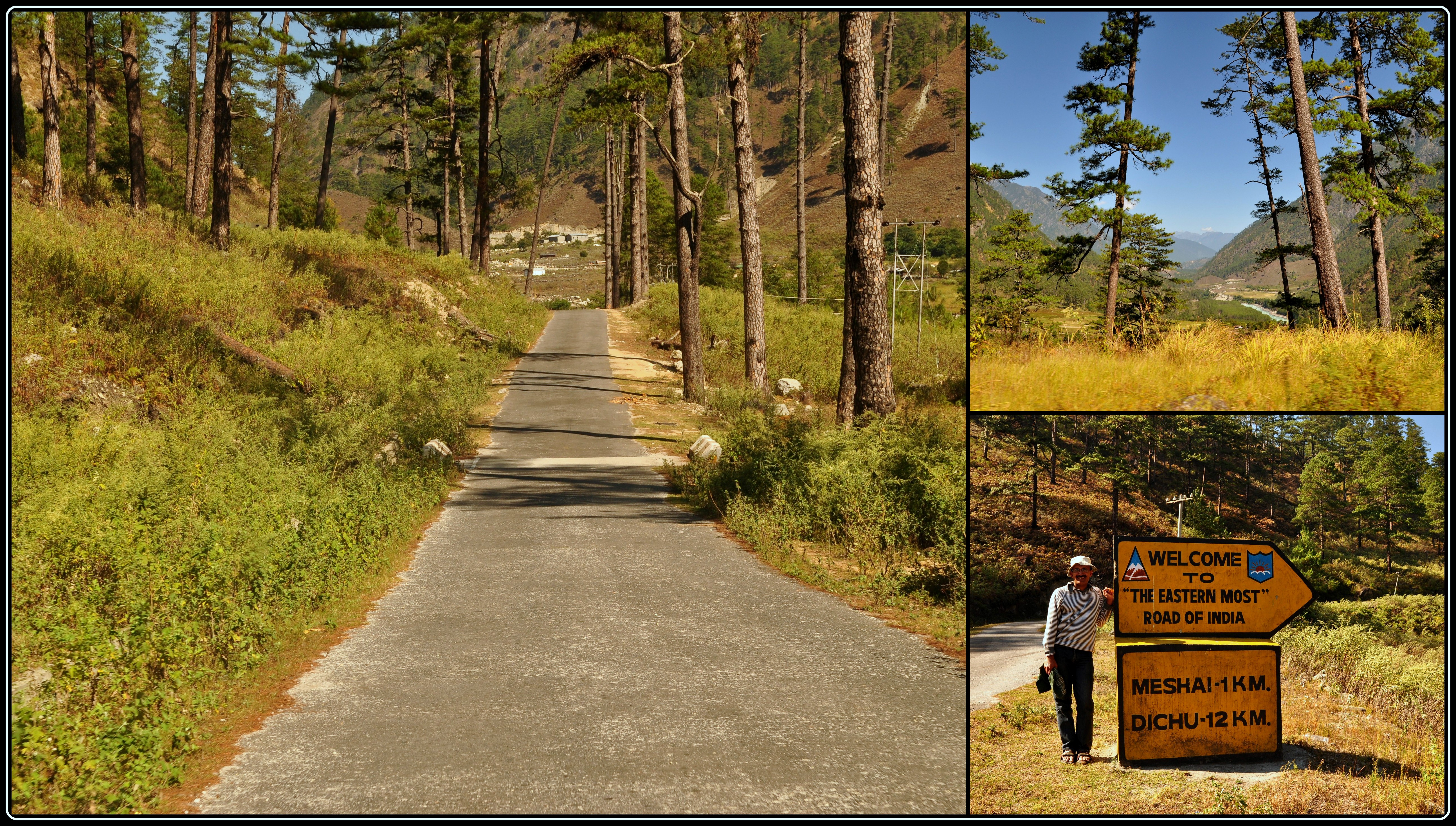
Our stopover at Digboi was followed by a drive through the towns of Ledo and Lekhapani till we got to the point that formally announced the beginning of the Stilwell Road.

The Stilwell Road begins here

This was where Arun had got to about 5 years ago and told us about the goosebumps he had felt. At around noon on the 6th of October, 2011, we were to feel the same. We were 12 km away from Jagun and 24 kms from Jairampur, the last town in Assam and the first in Arunachal, respectively.

Stilwell Road Map

We were handed over our Inner Line Permits at the Jairampur checkpost by none other Mr. Arif Siddiqui, an accomplished photographer and the man behind www.amazingarunachal.com, an excellent resource on Arunachal tourism. Mr. Phupla Singpho, our friend at Miao and who runs his own NGO promoting tourism in Namdapha, had helped us with these permits and, of course, our Namdapha visit later in the trip. Our documents found to be in order, we felt another ray of current pass through us as we stepped foot in Arunachal for the first time!

Entering Arunachal Pradesh

Lunch was at a smallish restaurant – more dhaba – and further on we passed the Assam Rifles cantonment.

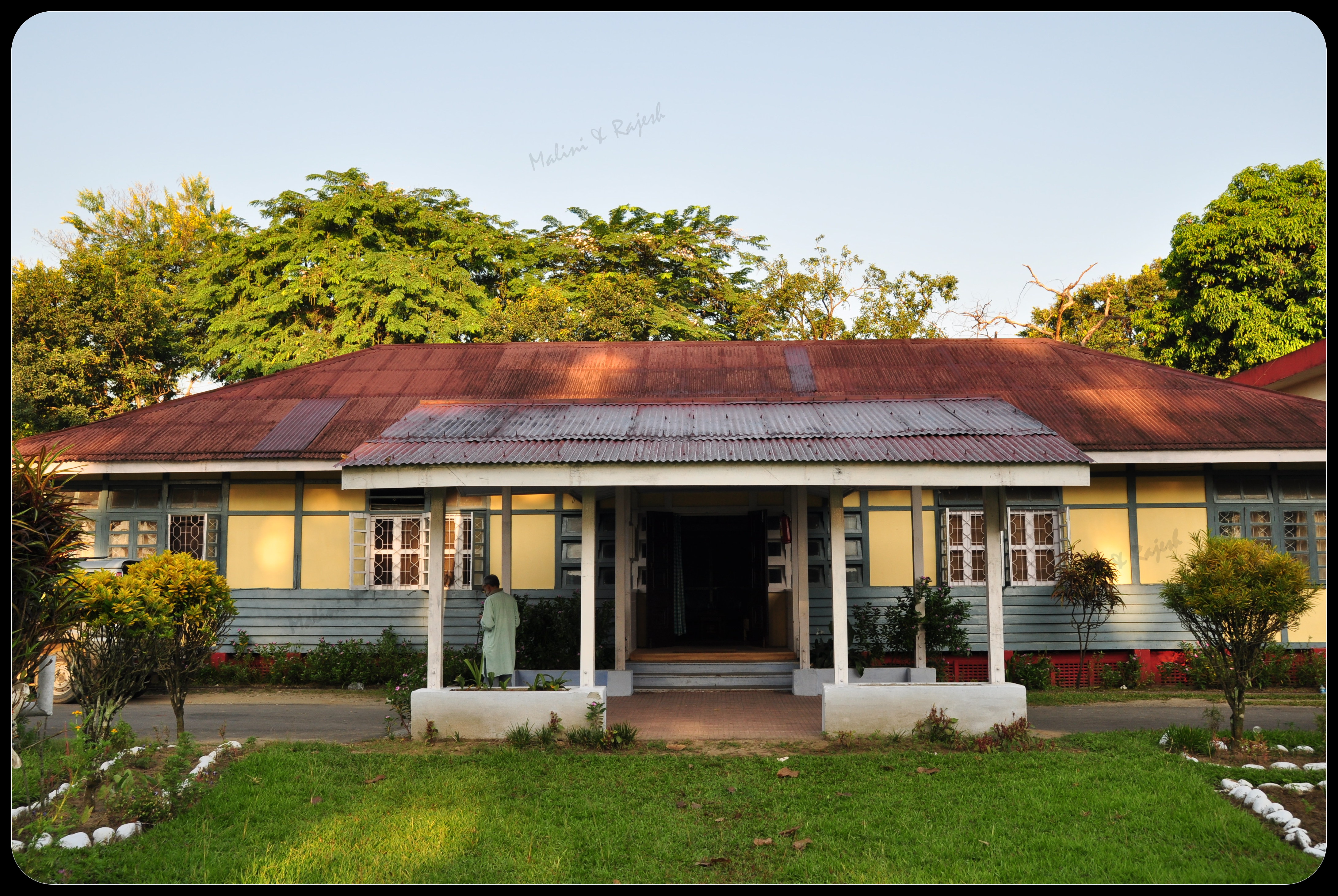
Our next stop was at the Vivekananda Kendra school where we had a wonderful meeting with the charming principal, Dubeyji and the administrator, Ramachandranji.

Vivekananda Kendra at Jairampur

One of the earliest in a pioneering chain of educational institutions in Arunachal, we saw up close the serene premises of VKV, Jairampur and walked around the classrooms, the boarding dormitories and met up with many of the students there.

Continuing on the Stilwell Road, we were now headed for the World War II cemetery. About 7 kms further down from Jairampur, we were driving slowly lest we should miss it in the thick overgrowth.

Entrance of the World War II Cemetery

But we were pleasantly surprised to see that it had now been bestowed some respect and had a prominent entry gate, making it hard to miss on your left.

Inside the cemetery

We spent some time among unknown gravestones and randomly meandering paths. It was somewhat eerie with the silence from the remoteness of the place and the fact that we were the only two living amidst the many departed and underground. After spending an hour or so with the martyrs, spotting a few butterflies and clicking a few photos, we left for Nampong, the easternmost Indian habitation on the Stilwell Road.

Nampong Inspection Bungalow

It was getting on dark and the road was, by then, taking a turn for the worse. Eventually, after being stopped briefly at an army checkpost, we drove into Nampong even as the sun was all but down. We were booked into the Nampong IB which was a little way above the market place and just before the checkpost that screens movement onwards to Pangsau Pass and Pangsau village.

Inside the Inspection Bungalow

The IB itself was a tidy arrangement, with an old wing and a new. There was ample parking space and the whole premises overlooked Nampong town, the surrounding mountain range and a brilliant sunset. We walked into the strains of music wafting about and were told that there was a music band that had drove in all the way from Guwahati to play in the Pooja pandal that was set up in town. And, post dinner, we settled down to some seriously elevated balcony seats, in the lawns of the IB, and watched and heard the band play to an appreciative crowd down below.

At the Checkpost - Pangsau Pass 12 km to go

We were up early morning and found Dasda giving his car a thorough wash. Packed, we were ready to head out to Pangsau Pass and be back before noon. Our chat with the IB staff, the previous night, had prepared us for some rather uninspiring news. We would not be able to cross over at the border and would have to miss the Lake of No Return and Pangsau village. Visitors from only either one of the nationalities could cross the border on a given day. It was a Friday and Fridays were Burma Day – which meant only Burmese villagers could cross over. Indians could go over only on the 10th, 20th and 30th of each month. If it weren’t a Friday, we could still have worked out some arrangement. Guess we would have to return to Nampong during one of the Pangsau Pass winter festivals – usually held in December – some other year.

On the road

After a brief stop at the checkpost outside the IB, we were flagged off. While we were waiting, we saw the first batch of Burmese villagers, with their baskets, walking up. Some were a little wary while others looked away but what caught our attention was they were nearly all women and children, hardly any of the menfolk.

We drove on through absolute wilderness. Wooded slopes dotted the hills around and the dust rose menacingly from the under construction road. In places, Joe’s road was as unmanageable as the Japs had been during those days. Dasda just took it all in his stride even as he kept up an amiable commentary on the region and its people.

All throughout, we noticed more but small batches of villagers walking in, chatting and giggling among themselves, unaware of clicking cameras from passing vehicles! Talking of passing vehicles, there were actually none other than ours. Except for a run down, open backed van that plied up and down and made a good fast buck out of the hapless villagers, saddled with their purchases on the way back. The going rate, Dasda added, was Rs. 100 per person for a ride.
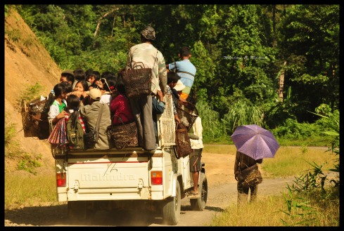
Taking a ride

We noticed something else. As a kind of travel insurance, the women had smeared their faces with some paste; apparently, this was to de-beautify themselves…strangely, leaving home is not always about looking good.

The old road and the new road

At one place, the road split into two. One of them, the more decrepit, was the old Stilwell Road while another, newer branch had carved its own modern day identity.

Indian Army screening the Pangsau villagers

We must have travelled about 12 km when we spotted a motley congregation ahead. We were at the border checkpost and the Indian Army was screening the Pangsau villagers. Sure enough, there were the green uniformed Indian guards, some of whom were busy checking documents. The large majority of the visitors just squatted and hung around all over, waiting for their one day permit that meant a week long stock of goods ranging from salt to clothes, bicycles to batteries and, yes, booze!

The mobikes

Over to a corner by the roadside, there were a dozen or so rundown mobikes without character or number plates, dumped to one side. These, we learnt, belonged to some of the more ‘affluent’ villagers who had, at least, saved on trudging the distance from their village to the border.

There were about fifity odd of the villagers and about half a dozen soldiers eyeing us. Dasda did the honors by introducing us to a senior Army man who promptly arranged for one of his men to escort us till the official border. Dasda chose to stay back and we set off with our new friend who seemed to carry his full rifle and a half smile with equal ease.

Being escorted to the border

With a shyness that didn’t quite gel in with his profile, he opened up with a little conversational support from me. Our escort, deferential but smart, was Baithye from Manipur and was currently posted to this outpost. There were not many Indian tourists, he told us, who made this journey. Of course, there were the villagers from Nampong and the crowds that thronged during the Pangsau Pass winter festival. But, I realized, it was only the oddball Stilwell enthusiast who dropped in and that wasn’t a number to worry the Indian Army much!

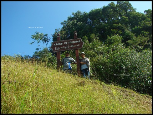
Pangsau Pass - Now and Then

We had turned a corner and were out of sight with the horde we had left behind. And, presently, we spotted the board I began this post with. We were at Pangsau Pass!

Teaching the shooter how to shoot!!

It was impossible not to freeze the moment and save it for posterity. We gladly let ourselves be shot by a soldier. Of course, he had tucked his rifle aside and gingerly felt his fingers around my D90 and fired the first round. I requested him to share the frame with me while Malini played soldier.

The sharp shooters??

We were now at the spot which, the board above us said, was the Indo-Burmese border. The checkpost of the Myanmar army was still a few hundred metres away, beyond another bend in the road. In the absence of a proper permit, reaching the Burmese checkpost was a no-no. We did, however, walk a few metres further on before turning back.

Talking India Looking Myanmar

Burma had just been a few strides away. Two kilometers across the checkpost lay the village of Pangsau and not too far away the mysterious, almost mythical, Lake of No Return. This waterbody gets its somewhat intriguing name from a piece of world war folklore that likens it to the Bermuda Triangle. It is said that, during WWII, an unverified number of Allied aircraft that flew over the lake had either crashed into it or simply disappeared. Adding to the mystery are also reports of soldiers, including those working on the Stilwell Road, having stepped into the lake and losing their lives. In fact, the Lake of No Return figured prominently in the joint scheme mooted by the Indian and Myanmar governments to promote tourism in the region. For now it had, tragically for us, become the Lake of No Entry!

Lake of No Return (Photo taken by Mr Arif Siddique, amazingarunachal.com)

Back at the Indian checkpost, we bid our new Manipuri friend goodbye and drove back. We passed more villagers – both on foot and cramped into the open vans – and wondered if there was any wonder that they ever felt for the road that had drawn us like a magnet all the way.

Shopping at Nampong market

As we drove back into the IB, we noticed a trickle of villagers leave the road, skirt the edge of the IB premises and take a shortcut down to the market below, saving them a couple of kilometers had they taken the road. For us, this was a once in a lifetime visit down Arun’s road. For them, the weekly hike was all about getting food, and other essentials, on the table back home.

Breakfast over, we were driving out of Nampong, headed for Miao for the Namdapha leg of our trip. As we passed the marketplace, Dasda slowed down to show us groups of Burmese villagers busily shopping around. They were huddling around hawkers, queuing up for liquor, flitting from one shop to the other…no one was a wanton tourist. There seemed a definite purpose to their long, painful international hike they made early morning.

Driving down the Stilwell Road for one last time (at least in this visit), we remembered Arun. Twice he had reached Nampong and turned back…only to come back and go the whole hog down the road that meant everything to him. He too had stayed at the Nampong IB, clicked himself to posterity at the sign board at Pangsau, went further down past the village and onwards to Myitkyina in Burma to reach Kunming in China.

Arun at Pangsau Pass in 2006

But his journey was still only half done. His travels on the road was just half his mission. The other half was the book he so wanted to write. All we have today, as Arun’s dream, are some photographs and a few opening chapters that he left behind. Going by that alone, it was clear that it would have had all the purpose that the Stilwell Road was meant to have. But, as with the road itself, all that we are left with is the beguiling aura, the undying charisma that Arun’s book holds in eternal promise.

Arun - The Intrepid Traveller


In Namdapha: Chasing the Butterflies

The alarm on my mobile phone was set at 4.30.  But I was woken up before that.  By a steam engine, of all things.

A steam engine in the middle of a jungle! The nearest railway station was about 90 km away, in Margherita, Assam.

Desperately seeking

I ran outside to see if the Hogwarts Express from Platform 9¾ had changed its course into this magical land. The sound was coming from somewhere up, from the branches of a tree. Seeing me dash outside in my night clothes, Gogoi da came out from the kitchen and joined me outside on the lawn. He pointed up and said “Hornbill”. At that very same moment two hornbills flew away flapping their wings vigorously.

I later learnt that the wing beats of a hornbill are so heavy that the sound produced by the birds in flight can be heard from a distance. When flapped, their wings create loud whooshing sounds that resemble the puffing of a steam locomotive starting up. Even their deep echoing calls can be heard from miles away.

Gogoi da rushed back to the kitchen to get us our tea and we walked towards the river to enjoy the dawn.

My alarm just went off. It was only 4.30 in the morning.

Does this look like 4.30 am!

The sun was rising somewhere behind the high mountains. But the golden rays were already making an impact on the sky and the river in front of us. It is hard to explain the way we were feeling – completely at peace, far away from the noises of the city, the honking, the shouting and yelling.

The Dapha Bum looming in the background

While sipping our tea we heard the loud whooping of hoolock gibbons. We followed the evocative call which led us into the woods behind the rest house. It was very difficult to judge from where the noises were coming, but the sounds got louder. It was as if they were somewhere right above our heads. But it was so hard to spot the gibbons through the thick foliage. It seemed as if more than one group were there and some sort of a hooting competition was going on. We had strained our necks for quite a long time so we decided to get back to the rest house.

It was barely six in the morning and so much had already happened. Such is the magic of Namdapha.

We had an early breakfast. Mr Pungjung had told us the previous day that if we had to spot wildlife we were to start early .

In the Kitchen, with Gogoi-da

So we set off from the rest house armed with our cameras, binoculars, a book on butterflies and a lot of enthusiasm along with our guide, Mr Pungjung.

Mr Pungjung had 33 years of service, out of which 18 years he had spent at Deban. And he didn’t even look 33.  There was a sprint in his walk, a twinkle in his eyes and he was always at least 50 m ahead of us, patiently waiting for us if there was something interesting to be sighted.

Mr Pungjung and his keen student

And interesting it was.

We took a shortcut from the guest house, cutting the hills and reached the Miao-Vijoynagar road and started walking towards Vijoynagar. Deban is called the 17th mile.  We had planned, or rather Mr Pungjung had planned, that we would walk till the 22nd mile to get some views of the mighty Dapha Bum.

In Namdapha

The jungle  was replete with bird calls.

We got to understand the spectacular bird life present here. In the small muddy streams we saw forktails hopping around, while other birds included the flamboyant  scarlet minivets, babblers, tree pies, barbets, patridges, kingfishers  ……..

Can the flora be behind?

The sun was climbing up, slowly. Till then we were passing through thick forest and the mud path was mostly covered with shade. Suddenly we came out to an open space, a small meadow, and realized how hot it was. But we did not feel the heat, as there was something that lay before us that cooled everything around us.

Butterflies.

Namdapha is a veritable butterfly paradise. Perhaps one of the prettiest insects on the planet,  butterflies embody the spirit of beauty and transformation in nature.

And what we found in front of us looked like a colour palette with multitonal hues and designs. Mr Pungjung started to identify the butterflies and I was busy noting them all down. Somewhere in the middle I gave up, the zoological names were distracting me from enjoying those fragile and pretty creatures.

Great Orange Tip’s, Common Five Ring’s, Chocalate Pansy, Evening Brown, Plum Judy, Common Mormon, Common Sailor and  Common Crows kept flitting by. The dragon flies and moths were not far behind.

I was distracted again, this time not by the Zoological names but by something more profound. It was the Gibbons again, those loud, coordinated, stereotyped duet song bouts had started again. Mr Pungjung said they were somewhere nearby.

We walked further up the jungle trail. The sounds got louder. And we spotted them. And ‘they’ consisted of a small happy family of a mother, father and child. The mother was  swinging from a branch with her baby clinging on to her, her husband watching her carefully from a neighbouring branch.

The man, woman and child

They suddenly disappeared into the thick forest cover and we moved on,  their sounds still haunting us.

On the way we found remnants of small fires that had been rustled up along the roadside. They had been made by people belonging to the Lisu tribe. About 157 km from Deban lies a small village called Vijoynagar. A succession of earthquakes, landslides and rains have made the settlement inaccessible and the only way to reach this village is on foot. Vijoynagar is inhabited by the Lisu tribe, who hunt forest animals. This has caused a lot of friction between the Lisus and the forest department. Poaching is common in these forests. There has been instances where Lisus have tried to exchange the endangered Red Panda for a packet of salt!

Remnants of a fire place

There are hardly any shops in Vijoynagar, so they have to trudge through the forests, cross the river, defend themselves from wild animals and sometimes walk in the rain to Miao to do all their shopping.

We met a few Lisus on our way, they carry bamboo baskets on their backs,  loaded with provisions walking slowly through the jungle. It takes them around 10 to 11 days to reach their village depending on the weather.

It is a long way home

It was already 12 pm and we started walking back. We were too engrossed with the forest sights, we totally forgot about the river flowing by, down in the valley.

The river and the valley

The sky was overcast and it looked as if it was going to rain. By 2.30 we were back at the guest house – and then it started to rain.

Famished, we decided to have lunch first.

Back at the cottage, we realised we had brought in some of the jungle’s fauna along. My husband took his socks off to reveal a particularly obstinate leech clinging on to his ankle – our first encounter with a bloodsucker. Fortunately, I had remembered my lessons…..a drop of saline and the little fellow dropped off, leaving behind a wet, red smear; our predator squiggling away for its next unsuspecting prey.

The prey and the predator

We sat by the river in the evening. It had been an eventful day.  The day’s excitement and tiredness began to take its toll. Before long we were asleep, lulled by the river flowing by and the occasional hoot of an owl.

The next day we were up before 5 am. This had become our daily routine – sleeping early, getting up even earlier – ever since we started our trip.

By 7.30 we were on the road, again. Today we were to walk towards Miao, as long as we could.

Across the river we spotted a small village with a lot of stilted houses. This village belonged to the Chakmas. The Chakmas are refugees from Bangladesh and are relatively recent immigrants, having been settled by the Indian government in the western edge of Namdapha.

The Chakma village across the Noa-dehing river

Mr Pungjung kept spotting animals and birds. By the time we came running with our cameras they conveniently disappeared. I did manage to capture a Malayan Giant Squirrel and a few hornbills flying by.

The Malayan Giant Squirrel

The patient trekker has a chance to see what he wants. The entire area is filled with songs of different species of birds –  from cuckoos to tree pies, redstarts to whistling thrushes, finches to sunbirds – the list is, happily, never-ending. The pretty flowers found in the shruberries and undergrowth added to the beauty of the forest. The oaks, the bamboo thickets, ferns and wild orchids all over.

Wild flowers on the way

A lot of road repair work was going on, a bridge was being revamped, ahead of the trekking season

There were surprises everywhere. A blue whistling thrush crossing the road, hornbills gliding over the tree canopy and a group of cape langurs enjoying their afternoon siesta.

Hornbills taking off

But it was time to go back. As we walked back we felt as if we were in a trance…taking the whole rainforest in.

But then I was reminded of a quote by Charles Darwin – “Delight is a weak term to express the feelings of a naturalist who, for the first time, has wandered by himself in a rainforest”. How true. Truer still, in this paradise called Namdapha.

But there was more to come. More to see. And more to know about.

The battle fields of Namti, near Walong.

Kaho and Kibithu – the eastern most villages of India.

Wakro and Tezu – our homes away from home.

Watch this space for more..


In Namdapha

It was 5 pm and the sun was already on the wrong side of the horizon. The flickering solar lights at the forest guest house we were staying at looked feeble from where we were standing. We were atop a small mound of sand overlooking the Noa-dihing River. The only sounds we could here were the occasional flaps from the birds, flying back home, and of the river making its way through its pebble-strewn bed.

We were at Namdapha National Park.

In Namdapha

Namdapha National Park is the largest wild life sanctuary in India, with a total area of 1985 sq km, and is located in the Changlang district of Arunachal Pradesh near the Myanmar border. This park is recognized as one of the richest areas in biodiversity and has the credit of being the northernmost evergreen rainforest.

Welcome to Miao

The previous evening we had reached Miao, a village located on the fringes of Namdapha. Miao is a small settlement with some modern government quarters, a few traditional Singpho houses,  a Buddhist monastery, a mini zoo and a museum, an inspection bungalow, an eco-tourist hut and a cute little market.

Miao market

Our friend and host, Mr Phupla Singpho, had already arranged for our stay at the eco-tourist hut for the night. He stays in his very modern concrete house with his family right opposite to his more traditional wooden family home. He has been instrumental in bringing global importance and interest to the Namdapha National Park.

The Singpho tribe of Arunachal Pradesh inhabit the district of Changlang and are mainly Theravada Buddhists.  They are traditional tea planters. The Singpho produce their tea by plucking the tender leaves and drying them in the sun and exposing them to the night dew for three days and nights. The leaves are then placed in a hollow bamboo and exposed to smoke over a fire. This way, their tea can be kept for years without losing its flavour. Mr. Singpho presented us with this ingeniously produced tea. I felt a bit awkward presenting him in return a plastic packet of Coorg coffee.

Eco-tourist Hut at Miao

After checking into our room at around 2 pm, we had a couple of hours before sun down. Yes, the sun sets in these regions very early and before 5 pm the street lights are on. There is a serious demand to have a separate time zone for the northeastern states with suggestions for advancing the clock by at least 90 minutes. This is because the day breaks early in the northeast with the sun normally rising way  ahead of other Indian cities. When we were in Miao in October, the sunrise was recorded at 5.05 am and the sunset at 4.55 pm, where as the same in Bangalore, where we stay, was recorded at 6.10 am and 6.07 pm, respectively.

The British were smarter. They had set the local time one hour ahead of IST for tea gardens, coal mines and the oil industry in these parts. Some of the tea gardens still follow the bagaan (garden) time!

The Buddha Vihara at Miao

Before sun down we decided to visit the Singpho monastery nearby. We were welcomed by a group of dogs who were loitering around the monastery.

The Altar

The monastery itself is an imposing structure painted with vibrant colours of yellow and maroon. Narendar Bhikku, the head monk, was kind enough to spend some time with us, even presenting us with a book on Buddhism.

The Monk and his audience

He had been staying at this monastery for more than 40 years. The altar had numerous idols of Buddha and there was a stupa and a Bodhi tree outside.

The museum and the zoo were already closed, so we walked back to the eco-tourist hut, had dinner and slept early.

Bodhi tree

About 25 km and 2 hours from Miao lies Namdapha National Park, a wildlife enthusiast and biologists’ dream come true. The next day, we stocked up on our dry provisions from the market and started our journey around 8 am in a Tata Sumo. The road on the way is so bad that only the bigger vehicles dare to venture into the forest. We were first stopped at a check post manned by the 18 Assam Rifles. The army is overpowering with its presence in Arunachal Pradesh and you can be stopped at any check post. Visitors entering the state are checked for their Inner Line Permits and Tourist Permits that must be obtained before entering the Namdapha National Park.

On the jungle path

Our host had arranged for our stay at Deban, the forest headquarters within the park and the only accommodation option at Namdapha.  The drive takes you through a jungle path that may take about an hour-and-a-half, depending on the state of repair of the roads or the intermittent landslides that occur in these regions. We were lucky not to face any landslides. We crossed the bridge over the Noa-dihing River, some traditional houses on stilts on the edges of paddy fields and reached M’Pen stream, a perennial stream that normally overflows during the rains.

On the way to Namdapha

Our driver said that visitors to Namdapha during monsoons often have to wait for up to two days for the stream to subside before it can be crossed by their vehicles. Sometimes one might even have to start walking from the M’Pen stream which forms the boundary of the park. As soon as we crossed the stream we reached the park entry gate and our credentials were checked by the Forest Department staff posted there.

M'Pen gate: The entrance to Namdapha Park

The rest of the journey took us through a thick jungle. It seemed as if the sun had already gone down, and it was not even 9 am. On one side of the jungle path there were tall trees rising up to 100 m above us with a thick undergrowth of ferns, cane and bamboo. On the other side beyond a gorge, the Noa-dihing river was following us.

Parvatheshwar Temple

We passed a small temple, turned a curve and reached a cross road. There were two roads, one going downhill to the forest guest house at Deban and the other going uphill all the way to Vijoynagar, 157 km away, right on the India-Burma border.

At the crossroads...

We followed the road downhill and reached our home for the next three days and nights. The Deban Rest House is located within the Namdhapa National Park and is managed by the Forest Department of Arunachal Pradesh. The rest house stands on a thickly wooded hill slope overlooking the Noa-dihing River. The mysterious forest seems to engulf you and certainly there can be no better option for the adventurous.

The Forest Guest House

We were booked into a double room on the ground floor in this conical shaped rest house. The more luxurious top floor rooms were meant for government officials and VIPs. Because we were neither, we settled for what we got which was the next best.  Tourist huts, dormitories and traditional huts are located away from the main structure towards the river. Right next to the main rest house is a mess room where meals are prepared by Gogoi da and his efficient team.

There is no electricity in the park. The rest house is electrified by solar powered batteries. There is no public telephone service in Deban and our mobile phones were happily hibernating inside our backpacks.  Once a day, and if any emergency arises, a wireless is used to communicate with the outer world.

Namdapha Park is unique in many ways.  Declared a Project Tiger reserve way back in 1983, this is the only park in the world which has all the four big cats; the Tiger, the Leopard, the Snow Leopard and the Clouded Leopard. The reason being the region’s varying altitude, it ranges from 200 m to more than 4500 m. The Dapha bum, the tallest peak in Arunachal, overlooks the park and is snow covered during winters. Namdapha is also home to India’s only ape, the Hoolock gibbon. And the most unique factor – Namdapha is one of the few national parks in India which you can explore only on foot.

The first thing to keep in mind when you set out to explore this area is that you must do it in the right season. In the monsoons the jungles are inaccessible, the river uncrossable and the blood-sucking leeches are out on the grounds and tree tops looking for preys. Yes, on the tree tops. There are about 5 species of leeches and some can even sense the human blood from about 10 feet away. There are leeches that hide in the ferns and branches and jump onto you from above!!

The river, the mountains and the landscape

We visited Namdapha in the right season. The river was flowing low, it was not the rainy or snowy season, but the forest staff were a bit behind schedule in clearing the jungle. It is an annual ritual of the forest staff to clear the jungle by marking well-defined trails for the convenience of the trekkers and wild life enthusiasts. There are camping sites inside the jungle at various places.

Butterflies near the guest house

Entering the jungle was out of the question for us. But the rest house surroundings is a mini zoo in itself. The whole place was swarming with butterflies, and it was not even season. The constant sound of the crickets seemed like an alarm clock that somebody forgot to turn off. And there was even a small snake lurking among the bushes right in front of our room even as we were checking in!!

Be my guest

By the time we had checked in and freshened up, it was time for lunch. After lunch we decided to explore the park by ourselves. We walked up the road on which we had come down a few hours earlier. The sounds of the jungle were mesmerizing.

On the jungle trail

A lot of birds were singing, hooting and clucking away merrily in the foliage. The constant sound of the river flowing by, adding up to the melody. As is normally the case, it is so hard to spot birds and even harder to photograph them. The luck with butterflies were better.

Some of the fellas.....

The sun was going down slowly and we decided to walk to the river side. A small concrete platform was built overlooking the river. But we walked down further to the sand mound to get a better view. The mound makes a perfect natural watch tower to check the river below, giving you good views of the huge mountains across the river.

On the water front... Noa-dihing River

Right next to the watch tower is a huge tree belonging to the Ficus species that towers over the guest house with its height and appearance. The lower portion of the trunk is split and it looks as if the tree has two legs, ready to walk away.

Mr Tree on the move...

The sun was down in a few minutes and there was nothing to do other than enjoy the night sounds coming from the jungle – the occasional hoot from an owl, the crickets with their raucous calls and the cry of the barking deer somewhere nearby only enhanced the surreal nature of the surroundings. The sight of the huge yellow moon, whose glow surrounded the valley was overwhelming. We decided to turn in early as we had a long day ahead of us.

For the next two days we had planned to trek along the jungle road and had already spoken with the in house wild life enthusiast and expert Mr Pung Jung.

Tomorrow was going to be busy. There were butterflies to be captured (on lens), birds to be identified, and leeches to be dodged. And if lucky, we could even spot a Hoolock Gibbon, a Hornbill, or one of the four big cats……

I love to be optimistic.

Watch this space for more.


Bridges of Arunachal Pradesh

View of the Parasuram kund bridge in Arunachal

In the 1992 best seller, ‘Bridges of Madison County’, when National Geographic photographer Robert Kincaid drives his pickup truck through the hot and dusty dirt tracks of Iowa and turns into Francesca Johnson’s farm driveway looking for directions to the Roseman covered bridge, little did I know about the beauty and romance of the bridges of Madison county that would haunt me forever.

I found the same beauty and romance in the bridges of Arunachal Pradesh too.

Hanging bridge near Samdul in Arunachal

Arunachal Pradesh: the land of the dawn-lit mountains,  the land of the Hoolock Gibbons, the land of the Mishmi’s, Adi’s, Tani’s, Nishi’s and many other indigenous tribes, and the land of the fiesty Lohit river.

Hanging bridge near Walong in Arunachal

Someone had said that ‘Bridges are perhaps the most invisible form of public architecture’. But not in Arunachal Pradesh.

Hanging bridge on the way to Kaho in Arunachal

Bridging rivers, gorges, and valleys bridges have always played an important role in the history of human settlement by not only providing crossings over water, dangerous roads and cliffs, but also becoming ‘frames for looking at the world around us’.

Can you spot the missing planks?

The beauty of each bridge that we crossed in Arunachal Pradesh was inspiring. Each one had its own unique character. Whether we were driving or walking over them or passing under them, we were enamored by the beauty of the surroundings. Some of bridges were monuments on their own.

Got the message!

Some of the hanging bridges we crossed were made of bamboo and wooden planks, apart from the metal cables that ran along the side and connected them to the ends. The floor creaked and squeaked, the entire bridge sometimes swinging under our clumsy steps. Below, through the gaps of missing wood pieces, we could see the mighty turquoise Lohit river gushing and rushing loudly, leaving us breathless.

Hanging bridge near Hawai in Arunachal

And then you see school children running across barefoot, mothers with small babies on their back, villagers carrying loads of whatsnot in their bamboo baskets, looking at us suspiciously. Well, practice does make one perfect. But what about fear of heights. Must be non-existent in these places.

School kids crossing a suspension bridge near Samdul in Arunachal

A lot of the modern bridges in Arunachal are built by the Indian army and Border roads organisation.

Metal and concrete structures that are built to withstand the rains, landslides and the heavy army trucks. Though they do not have the beauty of  the hanging bridges, they do serve their purpose.

One for the Army

Have you heard about bridges that are not built? Bridges that are grown.

Maybe, some other time….