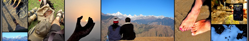
Half a century ago, India suffered its worst military attack, and subsequent defeat, throwing open a gaping hole at the border, and proving how unprepared India was, militarily and politically. On the 50th anniversary of the Chinese invasion, this post is dedicated to some of our bravest soldiers who fought, who died, and who went missing during Indo-China War, 1962.
*********************************************************************
In November 1962, TIME magazine paid a tribute to the Indian soldiers who fought in the Indo-China War in Walong. It said, ‘At Walong, Indian troops lacked everything. The only thing they did not lack was guts’.

Time Magazine November 30 1962 (ed)[http://www.time.com/time/covers/0,16641,19621130,00.html]

Rise and Shine – Walong Valley
From 22 October 1962 till the fall of Walong, on the 16th of November 1962, soldiers from the Sikh, Kumaoni, Gorkha and Dogra regiments fought a common enemy, shoulder-to-shoulder, in this unknown territorry. Ill-equipped and totally under prepared for such battles, some of the soldiers had to withdraw, crawling through the treacherous terrain. The rest of the soldiers never received any orders. Totally cut from their battalion, the soldiers fought it out to the last bullet, to the last man, till there was nothing left.
When the firing was over, and cease-fire declared, the army returned to the inhospitable terrain only to find that the Chinese had marked the positions of the dead. The Indian bunkers showed the dead where they had last manned their weapons. The Chinese had at least paid respect to their dead enemies – all the bodies were covered.
It is not uncommon to find the remains of the war, even now. Burnt pieces of army uniforms, fire arms, live ammunition, and other personal items lie scattered under rocks, tall grass and pine trees on the mountains.

People pay tribute to Sepoy Karam Chand Katoch (Inset) in Palampur [Photo Courtesy PTI]
How tragic that the selfless acts of bravery goes unknown to the majority of Indians?

Around the Walong circuit house
The next morning, up early, we drove further east. The first stop, just outside Walong town and past the Army complex, was the memorial built by the Lohit Brigade to salute the brave and selfless sacrifices made by the Army men during the 1962 war. Known as the ‘Hut of Remembrance’, here the names of each of the martyrs who had laid down their lives in defence of the Lohit valley in 1962 is etched in marble.

Hut of Remembrance at Walong
We spent a few minutes walking around the black marble plaques, reading the names of the young soldiers who fought on the rugged mountain tops, suffering from extremes of cold, hunger and thirst, only to lay down their lives for our better tomorrow. It was a sombre moment for both of us.
The war memorial and epitaph that I mentioned in the previous post stands on the Namti Plains, by the Lohit River, to commemorate the exemplary sacrifice of our brave soldiers.

At the hot springs in Tilam
But before visiting the war memorial we had to take a detour to Tilam. Just 4 km out of town, Tilam is known for its hot springs that, reportedly, have medicinal properties. On the banks of the springs a brand new circuit house was getting readied. We parked in front of the circuit house and walked down to the springs. Though a bit dirty, the water was boiling hot.

The hanging bridge on the way to Dong
We walked a bit further over a hanging bridge to where the climb up to Dong village begins. Overlooking Burma and China, this village has cornered the distinction of being the Indian habitation to catch the first rays of the sun. It’s a climb of an hour and a half hour which needs to be commenced at 3 in the morning, and not without a guide or a local.
It was in the turn of the last millennium when flocks of tourists swarmed to the hill top here to catch the first rays of the first sunrise of the 21st century light up the Dong valley and, in time, the rest of the country. We wanted to walk to ‘Millennium Point’ at Dong but we had to take permission from the Indian Army and without a permit no one could go.

Namti Plains
Promising that we would take the walk to Dong the next time, we climbed back into our vehicle. Our next destination was Kaho. On the climb up to Kaho, there was little traffic. The Namti plains stretched before our eyes, pretty and pine laden. After a brief stop at the war memorial we proceeded further.

War Memorial at Namti Plains
With every turn, the mountains on the Chinese side grew larger in view. The settings were so surreal. I was trying to imagine the place about 50 years back. A yellow board reminded us of being on the eastern most road in India.
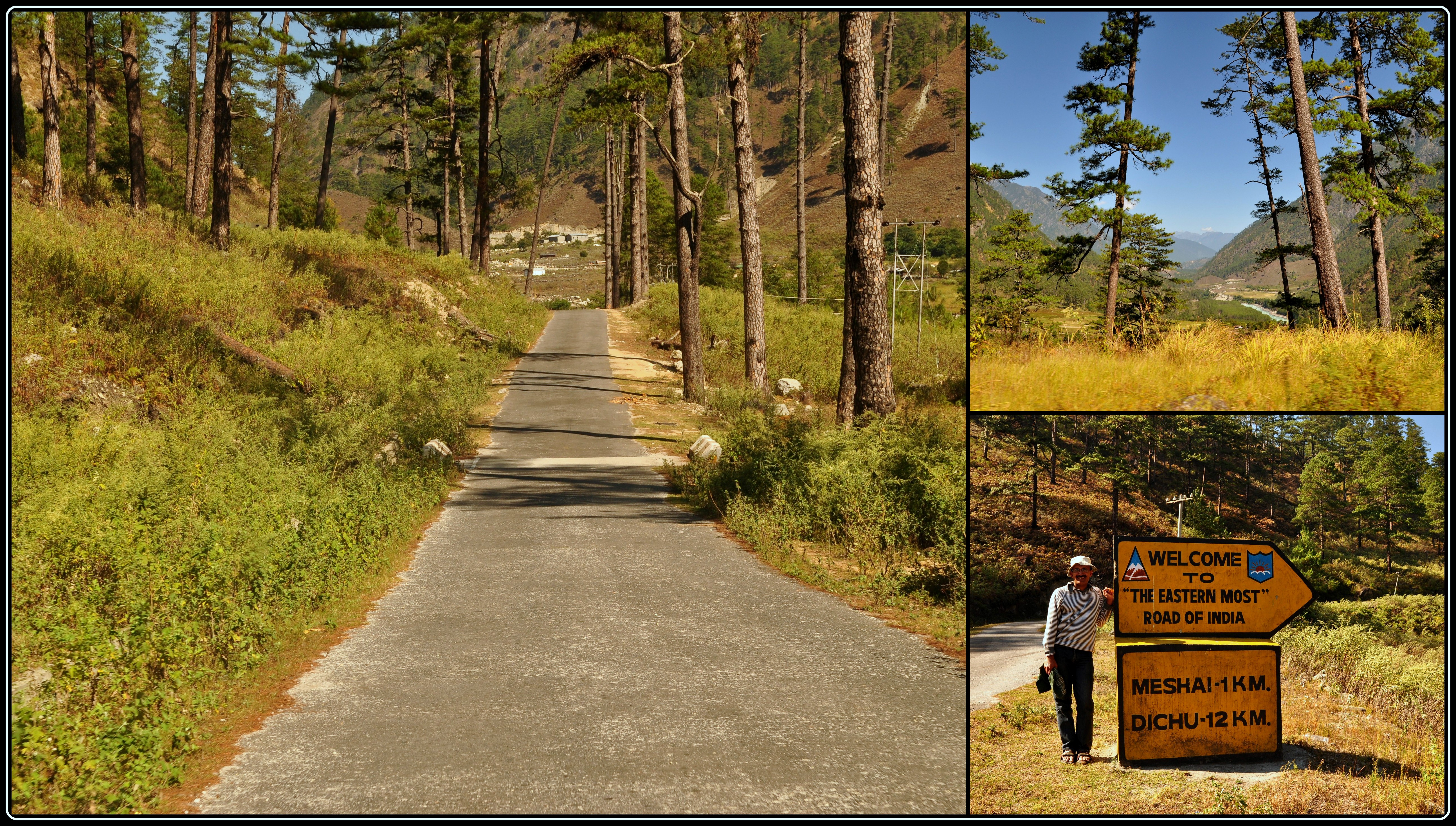
On the eastern-most road in India
We crossed a few metal bridges and were now driving along the Lohit River. Jayantoda mentioned that all these bridges had been replaced recently from the traditional ones. A ‘traditional’ one still hung precariously a bit further. We were standing in front of what the Mishmis call a ‘bridge’. In reality, it was just a lot of planks tied together that straddled both the banks of the Lohit. At that great height, the uncontrollable swing of the bridge and the turquoise water raging down below, a walk up to the other end and back needs some steely nerves. And I had to do it.

On the hanging bridge near Kaho
Mission accomplished, we drove into Kaho, a small village on the eastern most border, situated in a small valley surrounded by towering mountain peaks, most of them on the Chinese side. Kaho has around nine households. Cutting into the serenity of this small village is the constant presence of the Army all around and after all, the Line of Actual Control is not too far from here. Besides the village school, a monastery and a small tea shop cum PCO, Kaho is all about silence and the virgin beauty that the landscape offers.

Kaho village
We walked in to the Lohit Goodwill school and said hello to the children there. The teacher, apologetic about the poor attendance – the school had just reopened after Dushera – showed us into her class rooms. There were only four children, five were absent. The teacher herself had reached the previous night from Tezu, her home town, after the holidays.

Lohit Goodwill School
From the school we walked up to the monastery only to realize that it was closed. A short climb up from the monastery is an Indian Army outpost and we paid them a courtesy visit. The two jawans at the look out were gracious enough to point out where the border lies and the various peaks on both sides and allowed us a quick peek through their binoculars at Chinese side.
“I can see a house with blue paint”, I said triumphantly. “Well, the Chinese can see the print on your dress, Madame”, one of the jawan said teasingly. “They have a binoculars powerful than ours and they are constantly monitoring the civilian traffic in our area. If they see more traffic, they get stressed out and if they get stressed out, it indirectly affects our sleep”. For civilians like us this journey is just a picture in an album, a page in a book. For the army its the whole volume.

The blue houses on the other side
On the way back, we drove up to Kibithu, currently the brigade HQ of the Indian Army.

Kibithu
Here civilian entry is monitored if not entirely restricted. We had to give our details at the check post. The helipad here used to be an attraction for the great views it offered. Presently, it is out of bounds for anyone who is not army and photography is not permitted.

Kibithu – Army camp
We stopped for lunch in one of the small restaurants there. I never knew that the humble 2-minute Maggie could be so delicious.

The first glimpse of Lohit River entering into India [the furthermost mountains are in China]

Helmet Top [http://commons.wikimedia.org/wiki/File:Helmet_Top_Walong_Memorial_Arunachal_Pradesh.jpg]

Half way up the Helmet top mountain
We must have covered around 15 km, and the white war memorial building was visible through the pine trees up above. But luck seemed to evade us. A big rock now lay in front of us blocking the whole road. We didn’t even try to move it, it was that huge. Jayantoda said if it had been a kilometer or so we could have tried walking to the top. But this was a risk. We were trying to find the positive side in it. What if the rock had fallen after we had passed that way? We would have had to spend the night at Helmet Top. Dejected, we decided to turn back.
On the way down we stopped at a small water fall and plucked a few wild oranges that could not have been more sour.
We decided to walk around the town before sun down. We met the same kids we had seen yesterday and they insisted on not only taking a few more photographs of them but also seeing the pictures we had taken yesterday. In return I was presented with a few wild flowers.

Our little friends and their gift
The sun was going down and this was our last night in Walong. When I closed my eyes, trying to sleep, along with the mountains and valleys that came rolling by, a small poem composed by a Walong veteran kept ringing in my ears.
- The sentinel hills that round us stand
- bear witness that we loved our land.
- Amidst shattered rocks and flaming pine
- we fought and died on Namti Plain.
- O Lohit gently by us glide
- pale stars above us softly shine
- as we sleep here in sun and rain.
We had to come back another time, for we had promised ourselves a sunrise at Dong and a prayer at Helmet Top.


October 19th, 2012 at 3:59 pm
GREAAAAAAAAAT experince narrated in same great feelings. Such journey will remain unforgettable, if your heart is open for the unsung heroes of war and the people who are living (suffering only, isn’t it?) there without any so-called amenities.. Hats (Helmets!) off to you, our brothers and sisters..!
and thanks Malini for such virtual detour..
October 19th, 2012 at 4:59 pm
Thank you Alhad. I feel privileged (though with a heavy heart) to stand and salute on the soil where these brave hearts fought. Not to mention the people who are still living there.
October 19th, 2012 at 4:15 pm
നല്ല ബ്ലോഗ് മാലിനി…ഇഷ്ടമായി…
October 19th, 2012 at 5:01 pm
Thank you അപ്പുവേട്ടാ .
October 19th, 2012 at 4:41 pm
wow!!!
wat a wonderful narration and lovely images……makes me want to visit North East India…..the stories are very touching and amidst all the negativity in my country..reading such stories is heartwarming!!
http://sushmita-smile.blogspot.in/
October 19th, 2012 at 4:55 pm
Thanks Sushmita. If it makes you want to visit the North East, I guess its time you packed your bags :).
October 21st, 2012 at 8:44 pm
First, salutations to the Indian soldiers!! Awesome experiences Malini. Memorable ones. Great write up and photos.
http://www.rajniranjandas.blogspot.in
October 22nd, 2012 at 6:26 pm
Thanks Niranjan. Being the 50th year of war, this could not have been a better time to salute the soldiers.
October 23rd, 2012 at 10:57 pm
Ma, Walong for many, holds a magical spell, even if one has been visiting it many times. Such is the power of sacrifice and valour. I wish your account gets read wide by the youth of the country..
And just to add to your account, let us salute the men of these battalions that fought the Battle of Walong: 6 Kumaon, 4 Sikh, 3/3 Gurkhas and 4th Dogras. I’ve heard innumerable accounts of the bravery of 6 Kumaon, from my former colleague, who too was a captain in the Kumaon regiment…
The epitaph you quoted at the end is seen engraved on the first, but deeply moving, war Memorial ( built like a Mishmi tomb structure), on the river bank at Walong. The lines are composed by the then Political Officer (now known as Deputy Commisisoner) of Lohit district, Bernard S Dougal, soon after the war. I wish you would include this pic in your post! No visitor should miss this….
April 24th, 2013 at 3:09 pm
My dear Malini,
May I please be provided with contact no. of the great Uncle Moosa.
He is doing a great job for the society. This is his way of serving
the Nation.
Narender
Contact no:- 08295182000
April 28th, 2013 at 9:58 am
Sure Narenderji.
October 29th, 2012 at 8:59 am
wonderful post! loved reading every bit of it!
October 29th, 2012 at 10:44 am
Thanks Dishit for the comments and travelling along with me on my journey.
November 8th, 2012 at 5:18 pm
Wonderful journey and a honored salute to the martyrs.
I just wish those clubbed pictures that you have put could have been bigger ones and expanding the width of the blog text template would also help 🙂
I blog at http://adventureanytime.blogspot.in
November 8th, 2012 at 5:56 pm
Thanks Santosh for the comments. Will try and increase the width of the blog template. Regarding photos, to be frank, there are too many photos and I am too lazy to upload all of them, though I fell like showcasing all of them. A way I found out was to make a collage on Picassa and upload them. I’ll try and upload the unclubbed versions next time.
December 7th, 2012 at 1:06 pm
I have written about my Visit to Walong in another mail. This is just re-visit to add one correction.
The photograph (Number 9) you have posted here as ‘War Memorial at Walong’ is not at Walong, but at Namti plains, 7 KMs away from Walong.
The battle of Namti is famous for our soldiers’ fierce fight as wel as recapturing the area like Green Pimple, but had to loose in absence of ammunation!
The line ‘Walong will never fall again’ at the bottom of this memorial gives a healing touch only!
December 7th, 2012 at 3:13 pm
Yes the War Memorial in that photo is of the one in the Namti Plains. I will change the caption. We could not go near the war memorial in Walong that lies near the banks of Lohit. Some kind of a military exercise was going on that day. Thanks for pointing out.
March 18th, 2013 at 2:07 pm
An enjoyable and instructive account. Charming pictures. Most Chinese houses till Zayul (Rima of yore) have blue roofs. Till 1952 an Indian Trade Agent used to be posted in Rima and a Tibetan one at Sadiya (Assam).
March 18th, 2013 at 3:33 pm
Thanks Romesh for the comments and for stopping by my blog. You happen to know a lot about the north east frontier.
May 8th, 2013 at 8:12 pm
Hi malini,
We,me and my family, salute the brave soldiers
Congrats to the writer in you. It is after a long time we spoke. But Ifelt the same as if when we meet in C5 or in your house in Noida.
And the narration was super.
warm regards,
Siby.
May 9th, 2013 at 11:30 am
Thanks Sibi for the comments. Glad you liked the post. Its been a long time, but we still recall and reminisce the good times we had in Noida.
May 10th, 2013 at 12:06 pm
If you can do something for Kibithu then please raise the issue of mobile connectivity for this place which shall be a great help for the Jawans and the villagers living in these uncongenial conditions.
I am grateful to you for sharing your experience with the rest of the world but I ll be obliged to you if you can help raise the standard of life at this place.
Thanks
May 10th, 2013 at 12:32 pm
Hi Rakesh
Thanks for stopping by.
On paper it seems that Arunachal has a well connected network and is the only state in north east, which has VSAT connectivity and provides a vast range of services like mobile, landline, WLL and broadband. Various service providers like Airtel, BSNL, Aircel, Vodafone, Idea and Reliance, are supposed to provide uninterrupted network services to all. But as tourists we faced a few connectivity problems and our mobile phones were always in hibernation mode. For us it was just a matter of 21 days. I can understand the plight of the common man and the difficulty in getting across the network. The army has built roads to the most unimaginable corners of this state, I guess they should also help in strengthening the mobile connectivity.
November 23rd, 2013 at 12:25 pm
Superb one. Got the informations that i always wanted to know. A map added would have been a plus point.
Even Wikimapia is not able to show the area peoperly.
November 25th, 2013 at 12:30 pm
Thanks Taufique for the comments and the suggestion. When we planned our trip to Kaho and Kibithu we were also frantically searching for a map, just to get an idea of the place. Being a sensitive area, even Google maps and Wikimapia do not show the area properly. That is the main reason why I stayed away from posting a map.
October 13th, 2014 at 2:46 pm
Excellent account. As for maps – small scale maps that give you a very good idea of features like Dichu Gate are available with the Survey of India’s office on Janpath, New Delhi.
October 13th, 2014 at 5:58 pm
Thanks Romesh for the comments and information. Will pay a visit to the Survey of India office when in Delhi next time.
March 19th, 2015 at 8:25 pm
we are planing to visit kibithu with 3 of my freinds during the month of April,15. Your blogs article helped me to know more about Kibithu. Thanks. Arun, Assam
March 19th, 2015 at 10:38 pm
Thanks Arun. Glad to know that my blog helped. Happy travelling…